|
| June 26-27, 2001 Richmond, Virginia |
|
|
| The USGS, Office of Ground Water's Ground-Water
Resources Program is currently funding the Southwest
Ground-Water Resources (SWGR) project in the arid to semiarid basins
in the southwestern states of California, Nevada, Utah, Arizona, and New
Mexico. Although the climate and aquifer systems in the
Piedmont/Blue Ridge region differ from those of the southwestern states,
the study approach of the SWGR project was used as a template for the
discussion concerning the development of a science plan for the fractured
rock aquifers in the Piedmont and Blue Ridge.
The approach of the SWGR project consists of (1) a regional synthesis of hydrologic and geologic information in the region and (2) integration of several networked research projects on topics (ground-water and surface-water interactions, recharge determinations, effects of ground-water development on riparian systems, and climatic effects on ground-water systems) specific to the assessment of availability and sustainability of water resources throughout the Desert Basins of the Southwest. Examples from the SWGR website (http://az.water.usgs.gov/swgwrp/Pages/Overview.html) are shown below to illustrate the approach used by this project. |
 |
| Southwest Ground-water Resources |
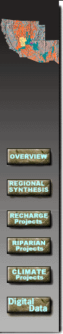 |
Regional SynthesisOne of the main aspects of the study is regional synthesis of hydrologic and geologic information from throughout the Southwest. The data are compiled and analyzed using geographic information systems (GIS) data sets, spreadsheet and statistical programs. A major priority of this part of the project is to characterize ground-water and surface-water systems in terms of the potential for future overdraft, the value to riparian ecosystems, and the characteristics of the aquifers that may lead to potential overdraft. Data synthesis and analysis of the regional synthesis study include (see examples at following links): Basin Categorization - GIS coverages are obtained or created to categorize the hydrologic setting of basins in the study area. Depth to Ground Water - Data on water levels are compiled from USGS and other sources. Hydrographs are plotted and GIS data sets (coverages) of depth to ground water are created for basins where data are available. Water-Use Data - Data on water-use are compiled from USGS and other sources to help evaluate changes in water use. Streamflow Data - Information on streamflow gaging stations are obtained and analyzed to illustrate base-flow conditions in streams for predevelopment and recent streamflow conditions. Land Use - Land use conditions are obtained for the study area to analyze the relation between land-use changes and hydrologic conditions.
|
|
| Southwest Ground-water Resources |
|
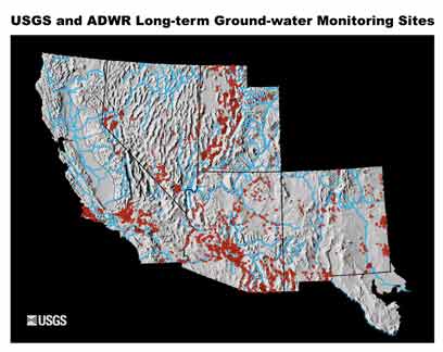
Regional Synthesis: Depth to Ground-waterWater-level
data for ground-water monitoring sites in the study area have been
compiled from U.S. Geological Survey databases and other sources.
Hydrographs that illustrate the water
|
|
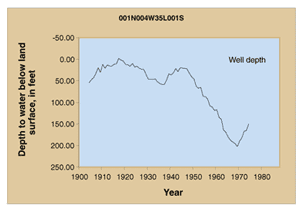 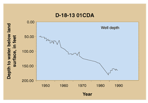 |
The water-level data are used to evaluate the impact of changes in land use and water use on the aquifer systems. Changes in ground-water levels may also represent aquifer system response to climate variability. Water-level data will also show areas where surface-water and ground-water interactions may play an important role in sustaining riparian habitat. | |
|
| Southwest Ground-water Resources |
 |
Recharge ProjectsThe objective of this part of the Southwest Ground-water Resources Project is to develop methods of quantifying ground-water recharge and ground-water/surface-water interactions. Recharge in southwestern alluvial basins occurs primarily along mountain fronts and in ephemeral and perennial streambeds where precipitation and runoff are concentrated and conveyed. In contrast, direct recharge through alluvial fans may account for the majority of recharge in many Basin and Range alluvial basins. The extent to which any location serves as a recharge (or discharge) area is a function of numerous factors, including lithology, slope, vegetative cover, climate, unsaturated-zone thickness, and hydraulic properties, and precipitation-event intensity and duration. As part of the effort to better understand recharge processes, the Southwest Ground-water Resources Project has developed both a networked series of studies and a set of individual studies. The five networked recharge study sites have been established to cover the five-state study area in the Southwest. For a synopsis of each project, check the Networked Recharge Studies map. The Individual Recharge Projects are concerned with the development of improved methods of quantifying recharge to ground-water systems from streams and application of these methods in the Southwest. Below is a table outlining each project.
|
|||||||||||
|
|
|
|
| Contact: dlnelms@usgs.gov U.S. Department of Interior, U.S. Geological Survey Privacy Statement Disclaimer URL: http://va.water.usgs.gov/PiedWkshop/example.htm Last modified: July 09, 2002 09:02:17 AM |
|