Defining the Largest Flow System of Relevance
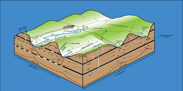
Groundwater flow in Appalachian Plateaus aquifers is characterized by short flowpaths, typically extending no more than tens of miles. Active flow occurs within a few hundred feet of the land surface where stress-relief fracture permeability is constrained near valley walls and under valley bottoms.
Regional flow is dominantly seated in valley bottoms (Booth, 1988) where stress-relief fracturing is superimposed on the regional hydrostratigraphic framework. In this convention, groundwater flow is controlled both by the regional dip of bedrock, local topography, and distal hydrologic boundaries coincident with large river valleys (Carswell and Bennett, 1963).
The scope of existing conceptual models needs to be expanded to include the contribution of underflow or regional structure on streamflow discharge and definition of saline-water boundaries. Mixing of shallow groundwater and deep formation brines along naturally occurring pathways as documented by Warner and others (2012) suggests that local frameworks provide limited transferability to address variability in water quality and water availability at scales exceeding a few tens of miles
See Also
For more information on the USGS Regional Groundwater Studies, please visit the USGS Groundwater Resources Program.