USGS - science for a changing world
Virginia DEQ

Virginia Water Science Center

 
  Duration Plot and Table of Daily Groundwater Levels
 
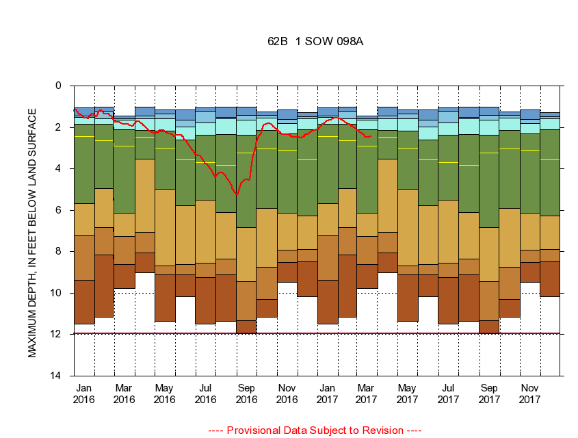
364126076003501 62B 1 SOW 098A
LOCATION.--Latitude 36°41'27", Longitude 76°00'35", North American Datum of 1927
                    Virginia Beach City, Va., Hydrologic Unit 03010205.
WELL CHARACTERISTICS.--Well is located in Columbia aquifer of Quatemary age. Depth 24 ft.
PERIOD OF RECORD.--Continual data, March 2004 to current year. Periodic data, June 1979 to current year.
DURATION STATISTIC COMPUTATION PERIOD.--All continual data through September 2015, all approved periodic data.
EXTERNAL INFLUENCE.--No known external influences.
GAGE OPERATION.--Virginia Department of Environmental Quality - Water Division.

     Duration Plot with Daily Groundwater Level Conditions
Provisional Data Subject to Revision
364126076003501 plot. 
62B 1
Provisional Data Subject to Revision


The current daily value for 03/22/2017 is 2.43 feet below land surface.

  explanation   Percentile Description Duration Plot Description 28 Day 14 Day 7 Day Daily


      Duration Table of Daily Groundwater Levels
           
Maximum depth below land surface, in feet


                364126076003501     62B 1

   Lowest Level
   5th percentile
 
   10th percentile
 
   25th percentile
 
 
   Median
 
 
   75th percentile


   90th percentile


   95th percentile


   Highest Level
         
Years of record
January
10.30
8.62
7.46
5.60
2.53
1.82
1.52
1.44
1.05
 
66
February
9.33
8.83
6.80
4.05
2.35
1.82
1.49
1.21
1.05
 
59
March
11.48
9.40
7.37
5.74
2.60
1.96
1.64
1.54
1.16
 
57
April
10.16
8.76
7.18
3.37
2.48
1.91
1.43
1.21
1.02
 
67
May
11.37
9.10
8.66
5.93
3.17
2.37
1.60
1.23
1.02
 
58
June
10.16
9.48
8.90
5.74
3.89
2.60
1.76
1.54
1.24
 
62
July
11.48
10.08
8.80
5.66
3.69
2.55
1.77
1.46
1.05
 
61
August
11.37
9.63
7.92
6.22
4.36
2.84
1.77
1.59
1.45
 
62
September
11.95
9.38
8.32
6.08
3.55
2.35
1.61
1.42
1.29
 
61
October
11.37
10.91
9.02
6.16
3.37
2.54
1.81
1.59
1.44
 
61
November
9.48
8.36
7.33
6.33
2.99
2.36
1.89
1.66
1.60
 
62
December
11.16
9.22
8.05
5.60
3.05
2.13
1.73
1.59
1.44
 
56
 
       
Instantaneous lowest water level for period of record = 11.95 feet below land surface.

The current daily value for 03/22/2017 is 2.43 feet below land surface.

---- Provisional Data Subject to Revision ----

Accessibility FOIA Privacy Policies and Notices

Take Pride in America logo USA.gov logo U.S. Department of the Interior | U.S. Geological Survey
URL: http://va.water.usgs.gov/duration_plots/daily/dp364126076003501.htm
Page Contact Information: Virginia WSC Webmaster
Page Last Modified: 6/19/2016