|
01614000
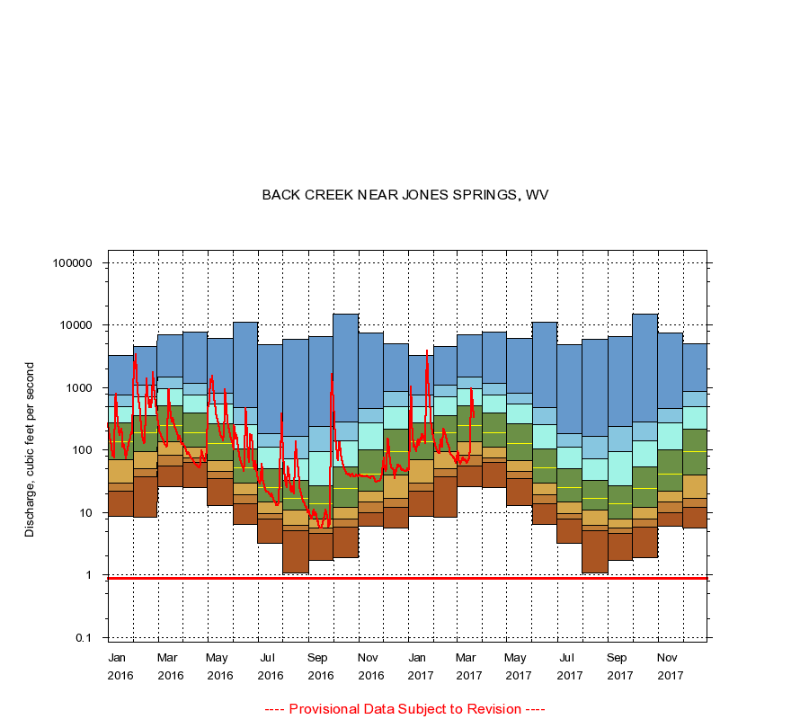
BACK CREEK NEAR JONES SPRINGS, WV
|
Minimum daily flow
|
|
|
5th percentile
|
|
|
|
10th percentile
|
|
|
|
|
25th percentile
|
|
|
|
|
|
Median
|
|
|
|
|
|
|
75th percentile
|
|
|
|
|
|
|
|
90th percentile
|
|
|
|
|
|
|
|
|
95th percentile
|
|
|
|
|
|
|
|
|
|
Maximum daily flow
|
|
|
|
|
|
|
|
|
|
|
|
Years of record
|
January
|
8.80
|
22.0
|
30.0
|
70.0
|
135
|
270
|
496
|
774
|
3,300
|
|
51
|
February
|
8.40
|
37.0
|
50.0
|
94.0
|
187
|
350
|
720
|
1,110
|
4,500
|
|
51
|
March
|
26.0
|
55.1
|
82.0
|
136
|
250
|
510
|
964
|
1,480
|
7,120
|
|
51
|
April
|
25.0
|
64.6
|
76.0
|
110
|
190
|
390
|
768
|
1,170
|
7,780
|
|
51
|
May
|
13.0
|
35.0
|
46.0
|
69.0
|
126
|
265
|
553
|
823
|
6,140
|
|
51
|
June
|
6.40
|
14.0
|
19.0
|
30.0
|
52.0
|
105
|
259
|
487
|
11,200
|
|
51
|
July
|
3.20
|
8.00
|
9.70
|
15.0
|
25.0
|
51.0
|
110
|
185
|
4,890
|
|
52
|
August
|
1.10
|
5.20
|
6.20
|
11.0
|
17.0
|
33.0
|
73.0
|
167
|
6,000
|
|
52
|
September
|
1.70
|
4.60
|
5.70
|
8.00
|
14.0
|
27.0
|
93.8
|
237
|
6,520
|
|
52
|
October
|
1.90
|
5.91
|
7.80
|
12.0
|
24.0
|
54.0
|
140
|
285
|
14,800
|
|
51
|
November
|
6.00
|
9.96
|
15.0
|
22.0
|
41.0
|
102
|
275
|
464
|
7,400
|
|
51
|
December
|
5.70
|
12.1
|
17.0
|
40.0
|
95.0
|
218
|
492
|
858
|
5,090
|
|
51
|
|
|
Instantaneous minimum flow for period of record =
0.90
cubic feet per second.
The current daily value for 03/22/2017 is 335.0 cubic feet per second.
----
Provisional Data Subject to Revision ----
|