|
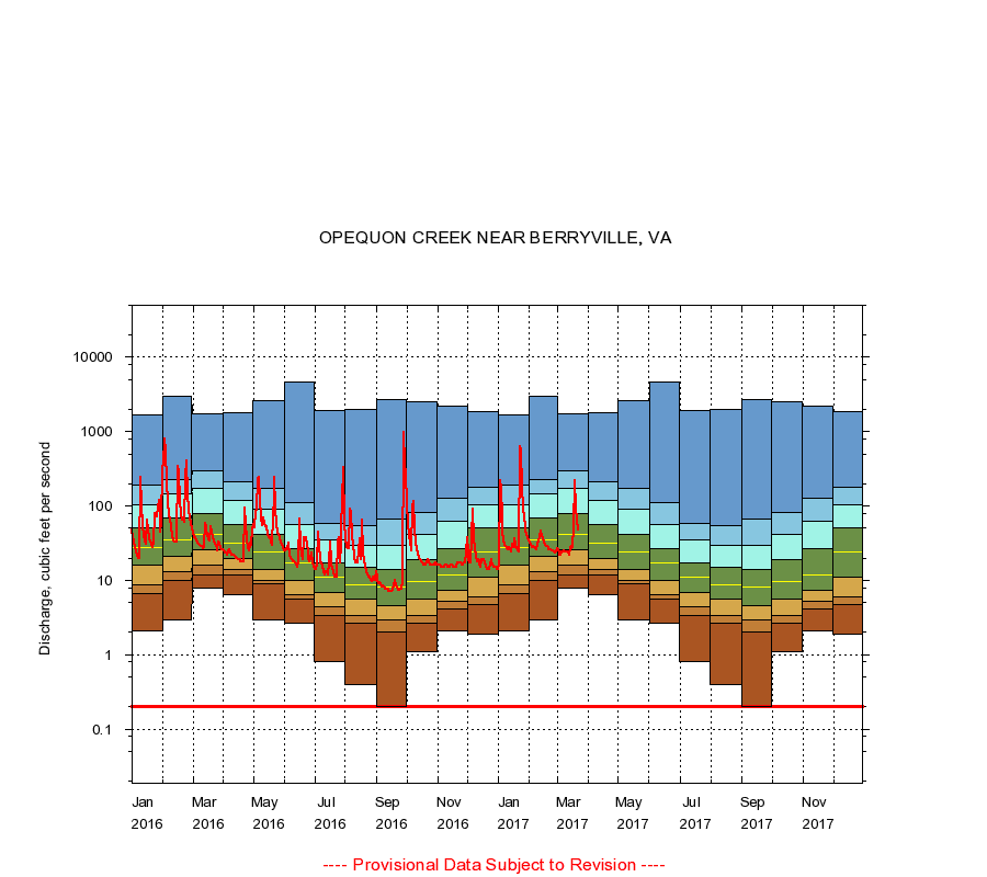
01615000
OPEQUON CREEK NEAR BERRYVILLE, VA
|
Minimum daily flow
|
|
|
5th percentile
|
|
|
|
10th percentile
|
|
|
|
|
25th percentile
|
|
|
|
|
|
Median
|
|
|
|
|
|
|
75th percentile
|
|
|
|
|
|
|
|
90th percentile
|
|
|
|
|
|
|
|
|
95th percentile
|
|
|
|
|
|
|
|
|
|
Maximum daily flow
|
|
|
|
|
|
|
|
|
|
|
|
Years of record
|
January
|
2.10
|
6.60
|
8.80
|
16.0
|
28.0
|
50.0
|
105
|
192
|
1,680
|
|
58
|
February
|
2.90
|
10.0
|
13.0
|
21.0
|
35.0
|
68.0
|
145
|
225
|
2,970
|
|
58
|
March
|
8.00
|
12.0
|
16.0
|
26.0
|
41.0
|
79.0
|
174
|
296
|
1,740
|
|
58
|
April
|
6.40
|
12.0
|
14.0
|
20.0
|
32.0
|
57.0
|
120
|
208
|
1,780
|
|
58
|
May
|
2.90
|
9.00
|
10.0
|
14.0
|
24.0
|
42.0
|
89.0
|
170
|
2,610
|
|
58
|
June
|
2.70
|
5.70
|
6.50
|
10.0
|
17.0
|
27.0
|
56.0
|
111
|
4,670
|
|
58
|
July
|
0.80
|
3.40
|
4.40
|
6.90
|
11.0
|
17.0
|
35.0
|
59.0
|
1,900
|
|
57
|
August
|
0.40
|
2.70
|
3.40
|
5.70
|
8.80
|
15.0
|
30.0
|
54.0
|
1,950
|
|
57
|
September
|
0.20
|
2.00
|
2.90
|
4.60
|
8.20
|
14.0
|
30.0
|
66.0
|
2,730
|
|
57
|
October
|
1.10
|
2.70
|
3.40
|
5.60
|
9.60
|
19.0
|
42.0
|
83.1
|
2,550
|
|
58
|
November
|
2.10
|
4.10
|
5.20
|
7.32
|
12.0
|
27.0
|
63.0
|
125
|
2,190
|
|
58
|
December
|
1.90
|
4.70
|
6.00
|
11.0
|
24.0
|
50.0
|
105
|
177
|
1,870
|
|
58
|
|
|
Instantaneous minimum flow for period of record =
0.20
cubic feet per second.
The current daily value for 03/22/2017 is 48.0 cubic feet per second.
----
Provisional Data Subject to Revision ----
|