|
01616500
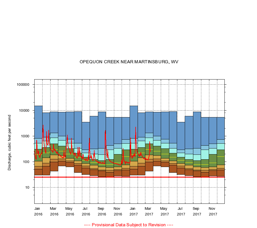
OPEQUON CREEK NEAR MARTINSBURG, WV
|
Minimum daily flow
|
|
|
5th percentile
|
|
|
|
10th percentile
|
|
|
|
|
25th percentile
|
|
|
|
|
|
Median
|
|
|
|
|
|
|
75th percentile
|
|
|
|
|
|
|
|
90th percentile
|
|
|
|
|
|
|
|
|
95th percentile
|
|
|
|
|
|
|
|
|
|
Maximum daily flow
|
|
|
|
|
|
|
|
|
|
|
|
Years of record
|
January
|
30.0
|
52.0
|
66.0
|
105
|
189
|
305
|
523
|
803
|
15,000
|
|
68
|
February
|
30.0
|
66.0
|
89.0
|
142
|
222
|
360
|
642
|
900
|
8,000
|
|
68
|
March
|
43.0
|
98.0
|
125
|
184
|
298
|
496
|
859
|
1,320
|
8,730
|
|
68
|
April
|
69.0
|
106
|
129
|
177
|
255
|
402
|
680
|
996
|
8,470
|
|
68
|
May
|
64.0
|
96.0
|
108
|
135
|
197
|
323
|
526
|
742
|
8,730
|
|
68
|
June
|
38.0
|
73.0
|
85.0
|
109
|
151
|
217
|
334
|
520
|
8,890
|
|
68
|
July
|
32.0
|
57.0
|
68.0
|
86.0
|
113
|
152
|
220
|
295
|
3,450
|
|
68
|
August
|
29.0
|
49.0
|
54.0
|
73.0
|
92.0
|
122
|
198
|
313
|
5,920
|
|
69
|
September
|
26.0
|
44.0
|
48.0
|
62.8
|
78.0
|
111
|
189
|
335
|
8,720
|
|
69
|
October
|
26.0
|
39.0
|
46.0
|
60.0
|
78.0
|
124
|
295
|
431
|
5,300
|
|
68
|
November
|
28.0
|
45.0
|
50.0
|
63.0
|
90.0
|
194
|
333
|
493
|
5,410
|
|
68
|
December
|
27.0
|
48.0
|
55.0
|
75.0
|
158
|
290
|
510
|
737
|
5,390
|
|
68
|
|
|
Instantaneous minimum flow for period of record =
25.0
cubic feet per second.
The current daily value for 03/22/2017 is 244.0 cubic feet per second.
----
Provisional Data Subject to Revision ----
|