|
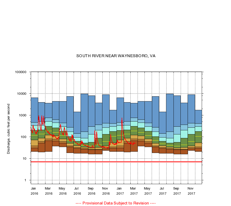
01626000
SOUTH RIVER NEAR WAYNESBORO, VA
|
Minimum daily flow
|
|
|
5th percentile
|
|
|
|
10th percentile
|
|
|
|
|
25th percentile
|
|
|
|
|
|
Median
|
|
|
|
|
|
|
75th percentile
|
|
|
|
|
|
|
|
90th percentile
|
|
|
|
|
|
|
|
|
95th percentile
|
|
|
|
|
|
|
|
|
|
Maximum daily flow
|
|
|
|
|
|
|
|
|
|
|
|
Years of record
|
January
|
21.0
|
31.0
|
38.0
|
71.5
|
118
|
196
|
329
|
459
|
6,390
|
|
63
|
February
|
20.0
|
51.0
|
60.0
|
88.0
|
134
|
208
|
343
|
517
|
3,930
|
|
63
|
March
|
21.0
|
65.7
|
80.0
|
120
|
186
|
304
|
521
|
750
|
3,630
|
|
63
|
April
|
37.0
|
64.0
|
77.0
|
110
|
159
|
258
|
455
|
620
|
4,400
|
|
63
|
May
|
34.0
|
52.0
|
60.4
|
79.0
|
115
|
182
|
302
|
433
|
4,430
|
|
63
|
June
|
18.0
|
34.6
|
38.0
|
50.0
|
68.0
|
103
|
174
|
274
|
7,430
|
|
63
|
July
|
17.0
|
29.0
|
32.0
|
39.0
|
48.0
|
62.0
|
94.6
|
142
|
1,410
|
|
63
|
August
|
17.0
|
27.0
|
29.0
|
33.0
|
40.0
|
51.0
|
87.0
|
174
|
9,670
|
|
63
|
September
|
16.0
|
25.0
|
27.0
|
31.0
|
37.0
|
56.0
|
132
|
297
|
8,110
|
|
63
|
October
|
16.0
|
25.0
|
27.0
|
32.0
|
42.0
|
87.5
|
201
|
361
|
3,730
|
|
63
|
November
|
23.0
|
28.0
|
32.0
|
38.0
|
60.0
|
131
|
267
|
427
|
9,070
|
|
63
|
December
|
21.0
|
30.0
|
34.0
|
53.0
|
105
|
176
|
295
|
417
|
1,710
|
|
63
|
|
|
Instantaneous minimum flow for period of record =
7.00
cubic feet per second.
The current daily value for 03/22/2017 is 49.0 cubic feet per second.
----
Provisional Data Subject to Revision ----
|