|
01626850
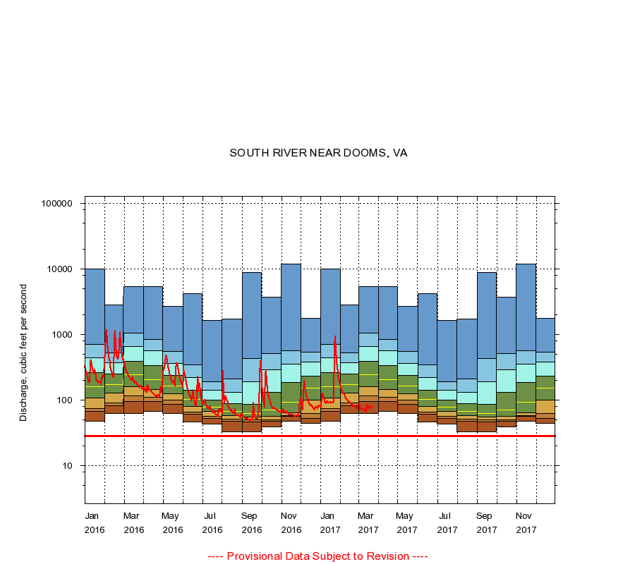
SOUTH RIVER NEAR DOOMS, VA
|
Minimum daily flow
|
|
|
5th percentile
|
|
|
|
10th percentile
|
|
|
|
|
25th percentile
|
|
|
|
|
|
Median
|
|
|
|
|
|
|
75th percentile
|
|
|
|
|
|
|
|
90th percentile
|
|
|
|
|
|
|
|
|
95th percentile
|
|
|
|
|
|
|
|
|
|
Maximum daily flow
|
|
|
|
|
|
|
|
|
|
|
|
Years of record
|
January
|
48.0
|
66.6
|
74.0
|
107
|
162
|
263
|
445
|
705
|
9,870
|
|
32
|
February
|
62.0
|
82.0
|
89.5
|
129
|
171
|
252
|
374
|
529
|
2,790
|
|
32
|
March
|
63.0
|
95.6
|
116
|
159
|
243
|
392
|
660
|
1,040
|
5,310
|
|
32
|
April
|
67.0
|
96.0
|
110
|
144
|
204
|
338
|
572
|
836
|
5,390
|
|
32
|
May
|
62.0
|
86.0
|
99.0
|
124
|
166
|
236
|
365
|
556
|
2,680
|
|
33
|
June
|
47.0
|
61.0
|
66.0
|
81.0
|
102
|
141
|
223
|
341
|
4,230
|
|
33
|
July
|
43.0
|
53.0
|
57.0
|
66.8
|
79.0
|
100
|
140
|
192
|
1,630
|
|
33
|
August
|
33.0
|
48.0
|
51.0
|
58.0
|
68.0
|
88.0
|
130
|
208
|
1,740
|
|
34
|
September
|
33.0
|
46.0
|
50.0
|
55.0
|
63.0
|
86.0
|
189
|
429
|
8,780
|
|
34
|
October
|
39.0
|
48.0
|
50.0
|
56.0
|
70.0
|
130
|
287
|
507
|
3,720
|
|
33
|
November
|
48.0
|
56.0
|
58.0
|
64.0
|
92.0
|
185
|
357
|
567
|
12,000
|
|
33
|
December
|
44.0
|
53.0
|
63.0
|
100
|
152
|
233
|
381
|
542
|
1,760
|
|
32
|
|
|
Instantaneous minimum flow for period of record =
28.0
cubic feet per second.
The current daily value for 03/22/2017 is 77.0 cubic feet per second.
----
Provisional Data Subject to Revision ----
|