|
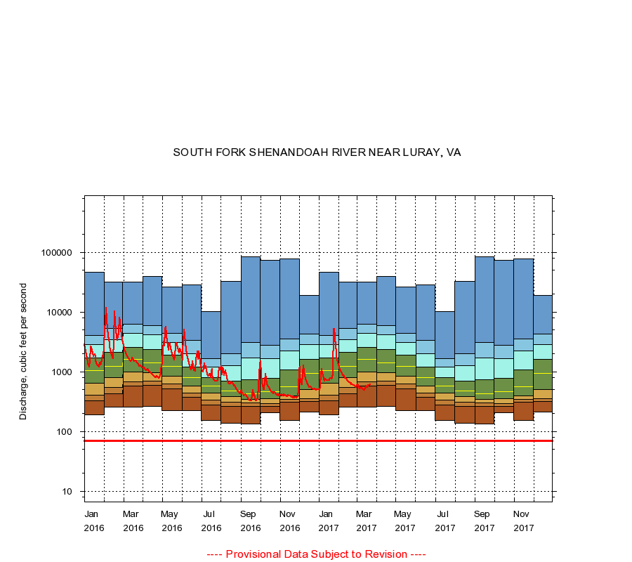
01629500
SOUTH FORK SHENANDOAH RIVER NEAR LURAY, VA
|
Minimum daily flow
|
|
|
5th percentile
|
|
|
|
10th percentile
|
|
|
|
|
25th percentile
|
|
|
|
|
|
Median
|
|
|
|
|
|
|
75th percentile
|
|
|
|
|
|
|
|
90th percentile
|
|
|
|
|
|
|
|
|
95th percentile
|
|
|
|
|
|
|
|
|
|
Maximum daily flow
|
|
|
|
|
|
|
|
|
|
|
|
Years of record
|
January
|
190
|
331
|
408
|
640
|
1,040
|
1,690
|
2,890
|
4,100
|
47,000
|
|
54
|
February
|
259
|
425
|
545
|
795
|
1,240
|
2,100
|
3,470
|
5,280
|
31,600
|
|
54
|
March
|
259
|
575
|
677
|
1,000
|
1,600
|
2,590
|
4,460
|
6,300
|
31,900
|
|
54
|
April
|
264
|
599
|
701
|
962
|
1,410
|
2,390
|
4,200
|
5,890
|
39,800
|
|
55
|
May
|
226
|
520
|
633
|
844
|
1,230
|
1,890
|
3,130
|
4,470
|
26,600
|
|
55
|
June
|
222
|
377
|
436
|
570
|
796
|
1,210
|
2,020
|
3,340
|
28,600
|
|
56
|
July
|
152
|
278
|
335
|
439
|
579
|
805
|
1,200
|
1,680
|
10,200
|
|
56
|
August
|
138
|
260
|
310
|
383
|
476
|
694
|
1,260
|
2,020
|
32,400
|
|
56
|
September
|
135
|
263
|
300
|
346
|
426
|
730
|
1,690
|
3,140
|
84,400
|
|
56
|
October
|
206
|
261
|
291
|
353
|
462
|
788
|
1,680
|
2,790
|
73,300
|
|
54
|
November
|
151
|
306
|
347
|
394
|
564
|
1,090
|
2,230
|
3,550
|
78,700
|
|
54
|
December
|
214
|
322
|
356
|
510
|
934
|
1,630
|
2,870
|
4,260
|
19,000
|
|
54
|
|
|
Instantaneous minimum flow for period of record =
70.0
cubic feet per second.
The current daily value for 03/22/2017 is 612.0 cubic feet per second.
----
Provisional Data Subject to Revision ----
|