|
01631000
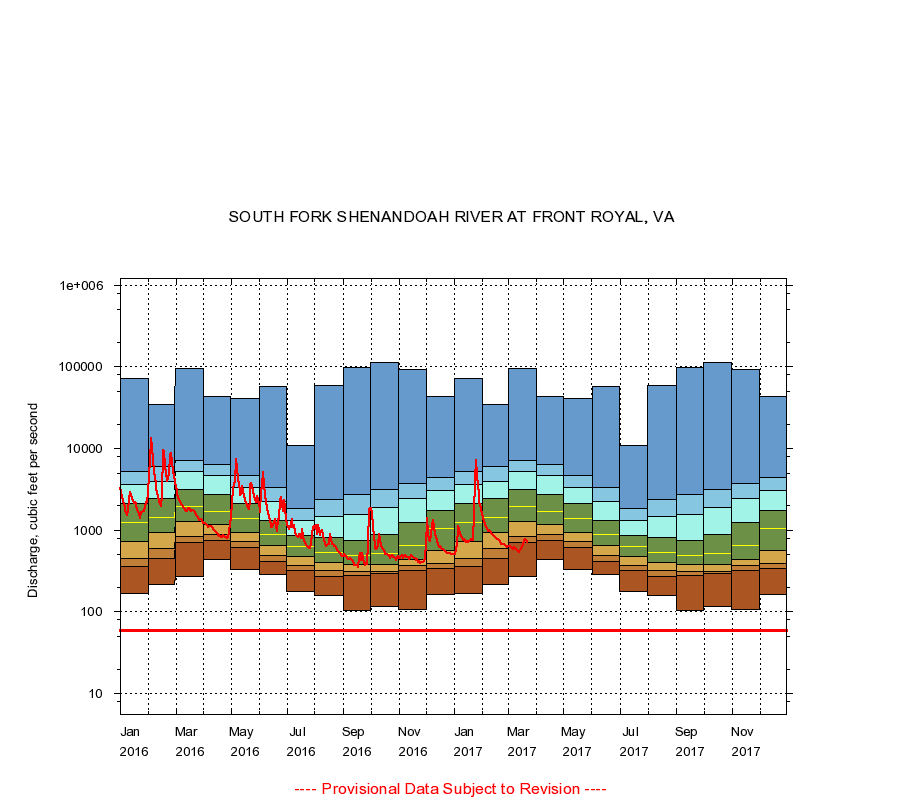
SOUTH FORK SHENANDOAH RIVER AT FRONT ROYAL, VA
|
Minimum daily flow
|
|
|
5th percentile
|
|
|
|
10th percentile
|
|
|
|
|
25th percentile
|
|
|
|
|
|
Median
|
|
|
|
|
|
|
75th percentile
|
|
|
|
|
|
|
|
90th percentile
|
|
|
|
|
|
|
|
|
95th percentile
|
|
|
|
|
|
|
|
|
|
Maximum daily flow
|
|
|
|
|
|
|
|
|
|
|
|
Years of record
|
January
|
170
|
362
|
449
|
738
|
1,250
|
2,150
|
3,610
|
5,200
|
71,400
|
|
85
|
February
|
217
|
448
|
592
|
930
|
1,450
|
2,450
|
3,930
|
5,960
|
35,100
|
|
85
|
March
|
268
|
703
|
850
|
1,270
|
1,960
|
3,200
|
5,240
|
7,220
|
96,400
|
|
85
|
April
|
442
|
758
|
886
|
1,170
|
1,700
|
2,780
|
4,670
|
6,390
|
43,700
|
|
85
|
May
|
331
|
610
|
721
|
934
|
1,400
|
2,120
|
3,390
|
4,710
|
41,600
|
|
85
|
June
|
289
|
416
|
485
|
654
|
890
|
1,300
|
2,230
|
3,390
|
57,000
|
|
85
|
July
|
176
|
325
|
372
|
476
|
633
|
856
|
1,300
|
1,840
|
10,900
|
|
85
|
August
|
160
|
274
|
320
|
409
|
533
|
810
|
1,480
|
2,380
|
59,300
|
|
85
|
September
|
103
|
280
|
311
|
386
|
497
|
758
|
1,560
|
2,720
|
98,200
|
|
85
|
October
|
118
|
292
|
315
|
385
|
520
|
876
|
1,920
|
3,200
|
114,000
|
|
85
|
November
|
107
|
322
|
368
|
444
|
644
|
1,240
|
2,420
|
3,720
|
92,400
|
|
85
|
December
|
162
|
341
|
390
|
563
|
1,040
|
1,740
|
3,090
|
4,490
|
43,700
|
|
85
|
|
|
Instantaneous minimum flow for period of record =
59.0
cubic feet per second.
The current daily value for 03/22/2017 is 714.0 cubic feet per second.
----
Provisional Data Subject to Revision ----
|