|
01632082
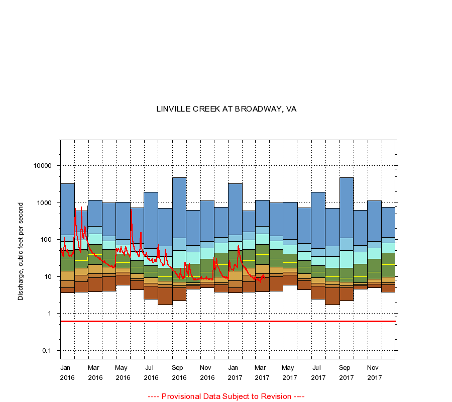
LINVILLE CREEK AT BROADWAY, VA
|
Minimum daily flow
|
|
|
5th percentile
|
|
|
|
10th percentile
|
|
|
|
|
25th percentile
|
|
|
|
|
|
Median
|
|
|
|
|
|
|
75th percentile
|
|
|
|
|
|
|
|
90th percentile
|
|
|
|
|
|
|
|
|
95th percentile
|
|
|
|
|
|
|
|
|
|
Maximum daily flow
|
|
|
|
|
|
|
|
|
|
|
|
Years of record
|
January
|
3.60
|
5.00
|
7.80
|
14.0
|
30.0
|
51.0
|
89.0
|
136
|
3,310
|
|
30
|
February
|
3.80
|
7.30
|
11.0
|
17.0
|
27.0
|
54.0
|
99.2
|
160
|
597
|
|
30
|
March
|
3.90
|
9.41
|
12.0
|
21.0
|
40.0
|
74.2
|
141
|
230
|
1,170
|
|
30
|
April
|
4.00
|
10.0
|
12.0
|
18.0
|
30.0
|
54.0
|
91.9
|
126
|
1,000
|
|
30
|
May
|
5.80
|
11.0
|
13.0
|
16.8
|
24.0
|
41.2
|
71.0
|
100
|
1,020
|
|
30
|
June
|
4.40
|
7.70
|
8.90
|
12.0
|
18.0
|
26.8
|
47.0
|
78.9
|
732
|
|
30
|
July
|
2.40
|
5.40
|
6.60
|
9.20
|
13.0
|
20.0
|
35.0
|
56.9
|
1,930
|
|
30
|
August
|
1.70
|
5.00
|
6.10
|
7.50
|
10.0
|
17.0
|
35.0
|
66.3
|
707
|
|
30
|
September
|
2.20
|
5.00
|
5.70
|
7.00
|
9.00
|
17.0
|
51.0
|
111
|
4,700
|
|
31
|
October
|
4.60
|
5.60
|
6.10
|
6.90
|
9.90
|
22.0
|
46.0
|
69.4
|
617
|
|
30
|
November
|
5.00
|
6.30
|
7.10
|
8.60
|
13.0
|
30.0
|
58.9
|
89.0
|
1,140
|
|
30
|
December
|
3.80
|
6.00
|
6.80
|
9.50
|
21.0
|
43.0
|
80.0
|
115
|
744
|
|
30
|
|
|
Instantaneous minimum flow for period of record =
0.62
cubic feet per second.
The current daily value for 03/22/2017 is 8.9 cubic feet per second.
----
Provisional Data Subject to Revision ----
|