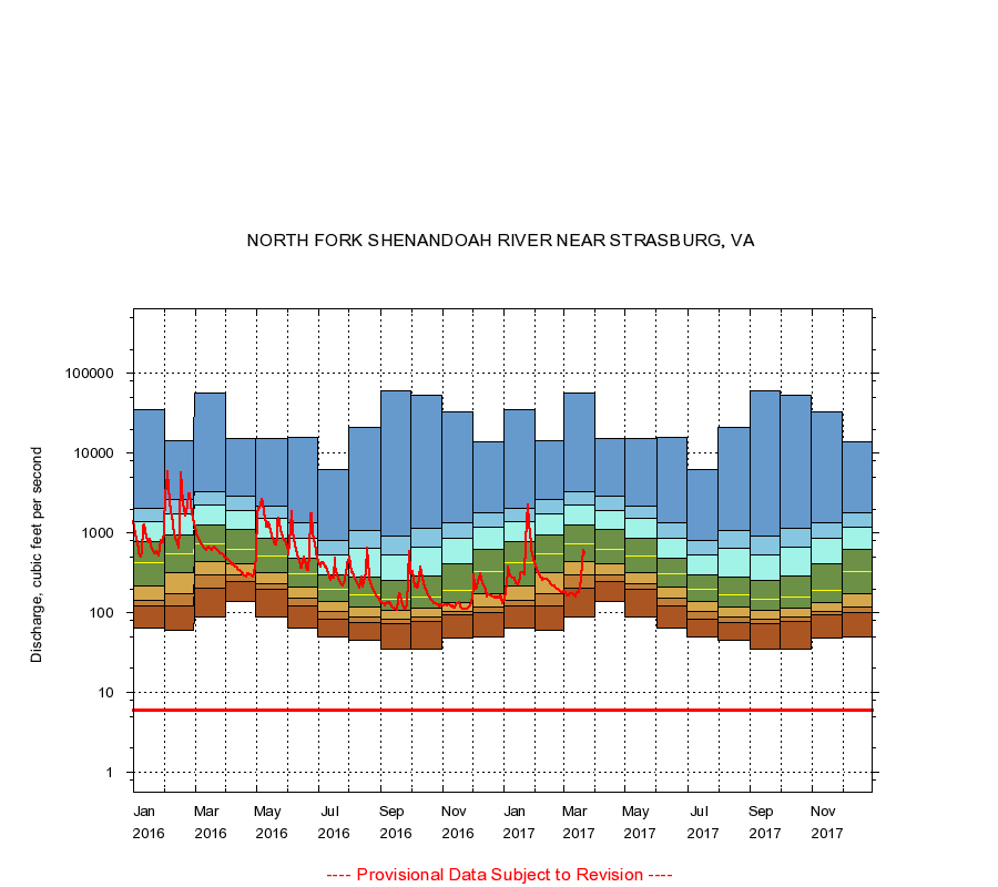
|
01634000
NORTH FORK SHENANDOAH RIVER NEAR STRASBURG, VA
|
Minimum daily flow
|
|
|
5th percentile
|
|
|
|
10th percentile
|
|
|
|
|
25th percentile
|
|
|
|
|
|
Median
|
|
|
|
|
|
|
75th percentile
|
|
|
|
|
|
|
|
90th percentile
|
|
|
|
|
|
|
|
|
95th percentile
|
|
|
|
|
|
|
|
|
|
Maximum daily flow
|
|
|
|
|
|
|
|
|
|
|
|
Years of record
|
January
|
65.0
|
120
|
142
|
220
|
430
|
770
|
1,370
|
2,020
|
34,700
|
|
90
|
February
|
60.0
|
123
|
175
|
322
|
548
|
938
|
1,730
|
2,590
|
14,300
|
|
90
|
March
|
89.0
|
201
|
295
|
442
|
736
|
1,280
|
2,240
|
3,310
|
56,500
|
|
90
|
April
|
139
|
244
|
296
|
407
|
630
|
1,100
|
1,930
|
2,870
|
15,400
|
|
91
|
May
|
89.0
|
194
|
229
|
323
|
517
|
870
|
1,550
|
2,190
|
15,300
|
|
91
|
June
|
65.0
|
121
|
154
|
209
|
310
|
490
|
850
|
1,360
|
15,700
|
|
91
|
July
|
50.0
|
84.0
|
105
|
139
|
200
|
301
|
528
|
810
|
6,310
|
|
91
|
August
|
45.0
|
75.0
|
88.0
|
119
|
168
|
282
|
639
|
1,070
|
21,200
|
|
91
|
September
|
35.0
|
73.6
|
84.0
|
108
|
146
|
257
|
530
|
903
|
60,700
|
|
91
|
October
|
35.0
|
77.0
|
88.0
|
113
|
159
|
286
|
654
|
1,150
|
52,500
|
|
90
|
November
|
48.0
|
95.0
|
105
|
133
|
190
|
415
|
862
|
1,340
|
33,000
|
|
90
|
December
|
50.0
|
99.0
|
117
|
174
|
331
|
619
|
1,200
|
1,780
|
14,000
|
|
90
|
|
|
Instantaneous minimum flow for period of record =
6.00
cubic feet per second.
The current daily value for 03/22/2017 is 547.0 cubic feet per second.
----
Provisional Data Subject to Revision ----
|

