|
01636500
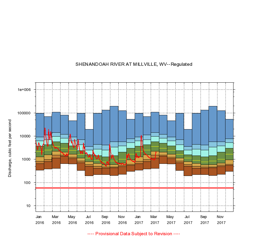
SHENANDOAH RIVER AT MILLVILLE, WV
|
Minimum daily flow
|
|
|
5th percentile
|
|
|
|
10th percentile
|
|
|
|
|
25th percentile
|
|
|
|
|
|
Median
|
|
|
|
|
|
|
75th percentile
|
|
|
|
|
|
|
|
90th percentile
|
|
|
|
|
|
|
|
|
95th percentile
|
|
|
|
|
|
|
|
|
|
Maximum daily flow
|
|
|
|
|
|
|
|
|
|
|
|
Years of record
|
January
|
340
|
640
|
822
|
1,290
|
2,140
|
3,720
|
6,180
|
9,020
|
95,900
|
|
101
|
February
|
380
|
795
|
979
|
1,580
|
2,540
|
4,200
|
7,090
|
11,100
|
70,000
|
|
101
|
March
|
409
|
1,130
|
1,510
|
2,240
|
3,520
|
5,650
|
9,560
|
14,100
|
109,000
|
|
101
|
April
|
652
|
1,360
|
1,520
|
2,050
|
2,980
|
4,900
|
8,120
|
11,900
|
80,400
|
|
101
|
May
|
628
|
1,070
|
1,230
|
1,640
|
2,470
|
3,770
|
6,240
|
9,020
|
45,900
|
|
101
|
June
|
328
|
701
|
856
|
1,140
|
1,610
|
2,400
|
4,250
|
7,120
|
97,300
|
|
101
|
July
|
194
|
500
|
590
|
801
|
1,120
|
1,580
|
2,510
|
3,560
|
19,500
|
|
101
|
August
|
217
|
410
|
492
|
674
|
909
|
1,440
|
2,770
|
4,380
|
94,900
|
|
102
|
September
|
217
|
412
|
465
|
580
|
768
|
1,280
|
2,480
|
4,080
|
133,000
|
|
102
|
October
|
200
|
429
|
472
|
592
|
849
|
1,450
|
3,330
|
5,660
|
192,000
|
|
101
|
November
|
225
|
480
|
567
|
697
|
1,010
|
2,060
|
3,830
|
5,770
|
125,000
|
|
101
|
December
|
300
|
540
|
615
|
950
|
1,680
|
2,960
|
5,190
|
7,570
|
52,600
|
|
101
|
|
|
Instantaneous minimum flow for period of record =
59.0
cubic feet per second.
The current daily value for 03/22/2017 is 2000.0 cubic feet per second.
----
Provisional Data Subject to Revision ----
|