|
01643805
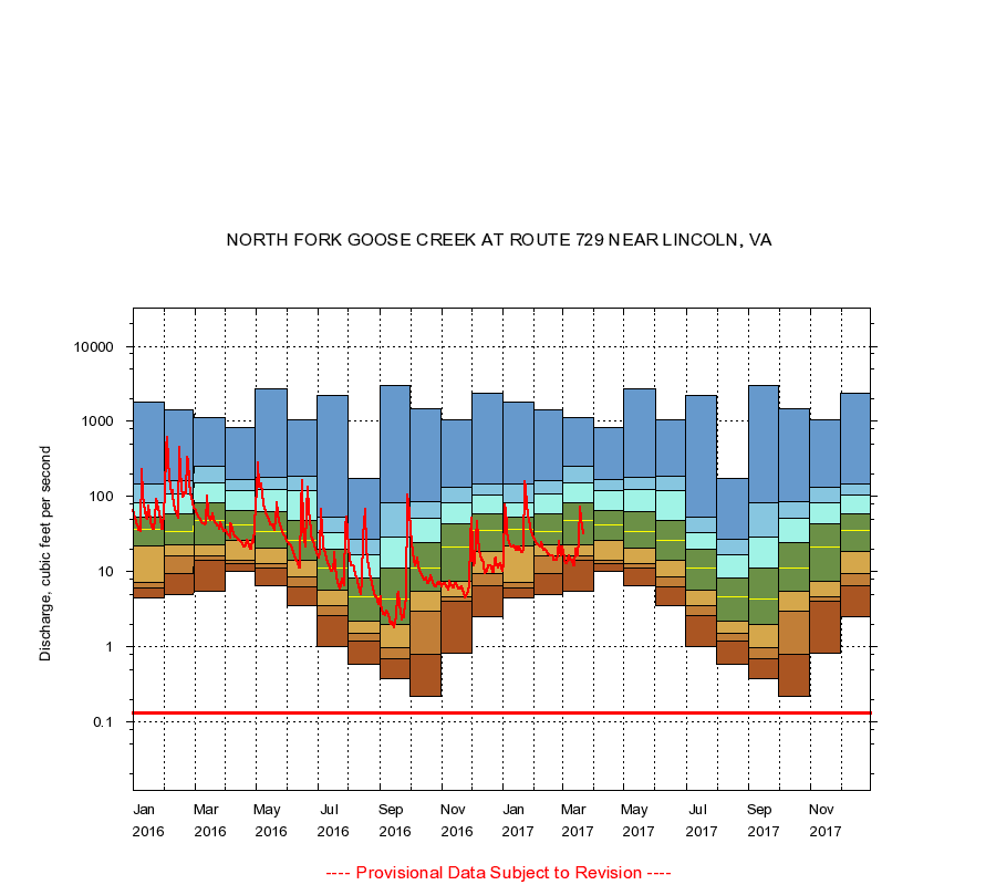
NORTH FORK GOOSE CREEK AT ROUTE 729 NEAR LINCOLN, VA
|
Minimum daily flow
|
|
|
5th percentile
|
|
|
|
10th percentile
|
|
|
|
|
25th percentile
|
|
|
|
|
|
Median
|
|
|
|
|
|
|
75th percentile
|
|
|
|
|
|
|
|
90th percentile
|
|
|
|
|
|
|
|
|
95th percentile
|
|
|
|
|
|
|
|
|
|
Maximum daily flow
|
|
|
|
|
|
|
|
|
|
|
|
Years of record
|
January
|
4.40
|
6.10
|
7.10
|
22.0
|
36.0
|
53.0
|
82.5
|
148
|
1,830
|
|
14
|
February
|
4.90
|
9.38
|
16.0
|
23.0
|
34.0
|
59.0
|
108
|
161
|
1,450
|
|
14
|
March
|
5.40
|
14.0
|
16.0
|
23.0
|
48.0
|
83.0
|
154
|
254
|
1,110
|
|
14
|
April
|
10.0
|
13.0
|
14.1
|
26.0
|
42.5
|
64.8
|
121
|
170
|
839
|
|
14
|
May
|
6.50
|
11.0
|
13.0
|
20.8
|
34.0
|
63.0
|
126
|
182
|
2,750
|
|
14
|
June
|
3.50
|
6.31
|
8.50
|
14.0
|
26.0
|
48.0
|
119
|
186
|
1,050
|
|
14
|
July
|
1.00
|
2.64
|
3.48
|
5.70
|
11.0
|
20.0
|
33.0
|
54.0
|
2,220
|
|
14
|
August
|
0.59
|
1.20
|
1.50
|
2.20
|
4.70
|
8.15
|
17.0
|
27.0
|
174
|
|
15
|
September
|
0.38
|
0.70
|
0.98
|
2.00
|
4.30
|
11.0
|
29.0
|
83.2
|
3,040
|
|
15
|
October
|
0.22
|
0.79
|
3.00
|
5.40
|
11.0
|
24.0
|
52.0
|
85.2
|
1,500
|
|
14
|
November
|
0.83
|
4.00
|
4.61
|
7.42
|
21.0
|
43.0
|
82.0
|
132
|
1,050
|
|
14
|
December
|
2.50
|
6.48
|
9.30
|
18.8
|
35.5
|
59.0
|
105
|
148
|
2,370
|
|
14
|
|
|
Instantaneous minimum flow for period of record =
0.13
cubic feet per second.
The current daily value for 03/22/2017 is 32.0 cubic feet per second.
----
Provisional Data Subject to Revision ----
|