|
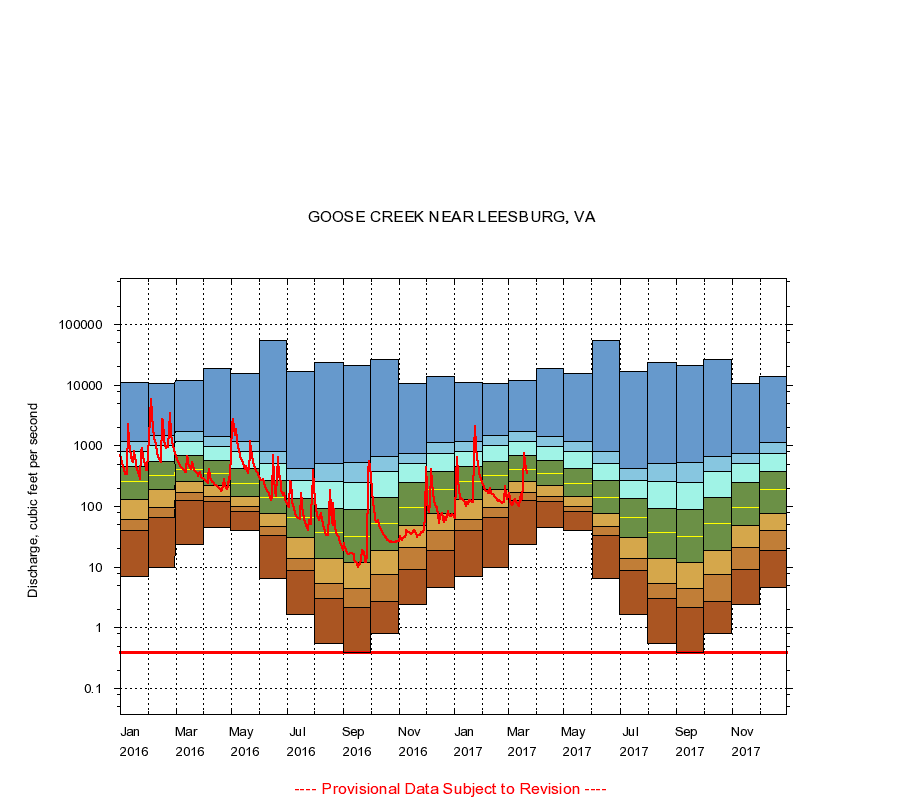
01644000
GOOSE CREEK NEAR LEESBURG, VA
|
Minimum daily flow
|
|
|
5th percentile
|
|
|
|
10th percentile
|
|
|
|
|
25th percentile
|
|
|
|
|
|
Median
|
|
|
|
|
|
|
75th percentile
|
|
|
|
|
|
|
|
90th percentile
|
|
|
|
|
|
|
|
|
95th percentile
|
|
|
|
|
|
|
|
|
|
Maximum daily flow
|
|
|
|
|
|
|
|
|
|
|
|
Years of record
|
January
|
7.00
|
40.0
|
62.0
|
130
|
257
|
459
|
805
|
1,180
|
11,100
|
|
89
|
February
|
10.0
|
65.0
|
97.5
|
192
|
325
|
553
|
994
|
1,460
|
10,800
|
|
89
|
March
|
24.0
|
128
|
168
|
255
|
413
|
700
|
1,160
|
1,740
|
11,800
|
|
89
|
April
|
46.0
|
120
|
148
|
221
|
349
|
570
|
960
|
1,410
|
19,000
|
|
89
|
May
|
40.0
|
83.0
|
102
|
144
|
239
|
423
|
794
|
1,190
|
15,400
|
|
88
|
June
|
6.60
|
33.0
|
47.0
|
78.2
|
142
|
270
|
516
|
812
|
53,600
|
|
88
|
July
|
1.70
|
8.84
|
14.0
|
31.0
|
67.0
|
135
|
271
|
424
|
17,000
|
|
88
|
August
|
0.55
|
3.10
|
5.40
|
14.0
|
38.0
|
92.0
|
256
|
510
|
24,000
|
|
89
|
September
|
0.40
|
2.20
|
4.40
|
12.0
|
32.0
|
90.0
|
253
|
528
|
20,800
|
|
90
|
October
|
0.80
|
2.70
|
7.70
|
19.0
|
52.0
|
142
|
385
|
656
|
26,100
|
|
89
|
November
|
2.40
|
9.06
|
21.0
|
48.0
|
97.0
|
250
|
520
|
760
|
10,700
|
|
89
|
December
|
4.60
|
19.0
|
40.0
|
76.0
|
188
|
383
|
744
|
1,130
|
13,900
|
|
89
|
|
|
Instantaneous minimum flow for period of record =
0.40
cubic feet per second.
The current daily value for 03/22/2017 is 344.0 cubic feet per second.
----
Provisional Data Subject to Revision ----
|