|
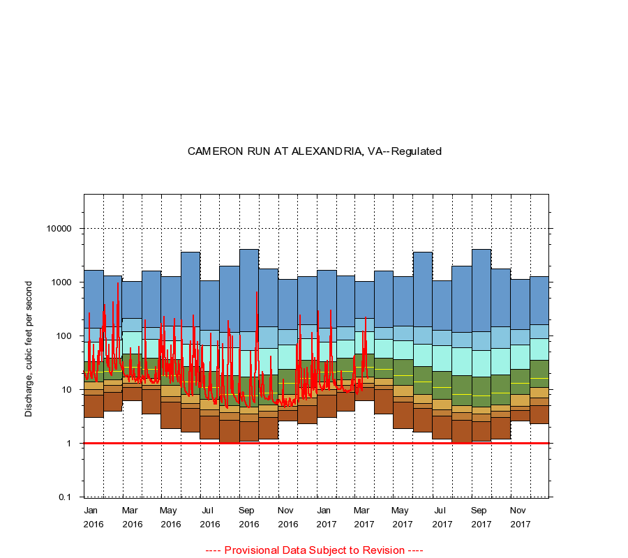
01653000
CAMERON RUN AT ALEXANDRIA, VA
|
Minimum daily flow
|
|
|
5th percentile
|
|
|
|
10th percentile
|
|
|
|
|
25th percentile
|
|
|
|
|
|
Median
|
|
|
|
|
|
|
75th percentile
|
|
|
|
|
|
|
|
90th percentile
|
|
|
|
|
|
|
|
|
95th percentile
|
|
|
|
|
|
|
|
|
|
Maximum daily flow
|
|
|
|
|
|
|
|
|
|
|
|
Years of record
|
January
|
3.00
|
7.88
|
10.0
|
14.0
|
21.0
|
33.2
|
75.5
|
140
|
1,660
|
|
54
|
February
|
3.90
|
9.00
|
12.0
|
15.0
|
22.0
|
39.0
|
84.0
|
149
|
1,330
|
|
54
|
March
|
6.20
|
11.0
|
13.0
|
17.0
|
26.0
|
46.0
|
120
|
209
|
1,040
|
|
54
|
April
|
3.50
|
9.96
|
12.0
|
16.0
|
23.5
|
38.0
|
85.9
|
145
|
1,610
|
|
53
|
May
|
1.90
|
5.80
|
7.50
|
12.0
|
18.0
|
36.0
|
82.0
|
153
|
1,290
|
|
53
|
June
|
1.60
|
4.50
|
5.50
|
8.20
|
14.0
|
27.0
|
71.0
|
149
|
3,680
|
|
54
|
July
|
1.20
|
3.20
|
4.20
|
6.50
|
11.0
|
22.0
|
66.0
|
129
|
1,080
|
|
54
|
August
|
1.00
|
2.68
|
3.70
|
5.10
|
8.20
|
18.0
|
61.0
|
118
|
2,020
|
|
54
|
September
|
1.10
|
2.50
|
3.50
|
4.70
|
7.60
|
17.0
|
53.0
|
119
|
4,090
|
|
54
|
October
|
1.20
|
3.00
|
3.90
|
5.20
|
8.60
|
19.0
|
58.5
|
149
|
1,770
|
|
54
|
November
|
2.60
|
4.10
|
4.90
|
8.00
|
13.0
|
24.0
|
67.0
|
131
|
1,130
|
|
54
|
December
|
2.30
|
5.00
|
7.00
|
11.0
|
16.0
|
35.0
|
90.0
|
164
|
1,260
|
|
54
|
|
|
Instantaneous minimum flow for period of record =
1.00
cubic feet per second.
The current daily value for 03/22/2017 is 16.0 cubic feet per second.
----
Provisional Data Subject to Revision ----
|