|
01660400
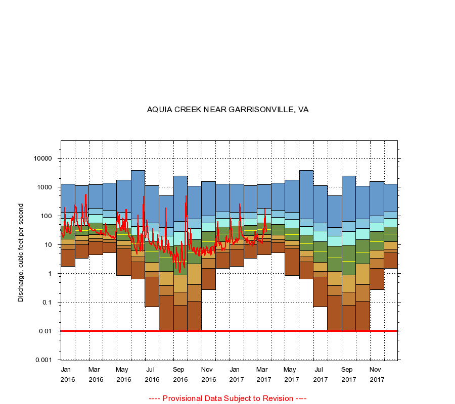
AQUIA CREEK NEAR GARRISONVILLE, VA
|
Minimum daily flow
|
|
|
5th percentile
|
|
|
|
10th percentile
|
|
|
|
|
25th percentile
|
|
|
|
|
|
Median
|
|
|
|
|
|
|
75th percentile
|
|
|
|
|
|
|
|
90th percentile
|
|
|
|
|
|
|
|
|
95th percentile
|
|
|
|
|
|
|
|
|
|
Maximum daily flow
|
|
|
|
|
|
|
|
|
|
|
|
Years of record
|
January
|
1.80
|
7.10
|
10.0
|
16.0
|
28.0
|
45.2
|
82.7
|
135
|
1,280
|
|
42
|
February
|
3.40
|
10.0
|
14.0
|
21.0
|
32.0
|
47.0
|
81.0
|
135
|
1,120
|
|
42
|
March
|
4.50
|
13.0
|
16.3
|
23.0
|
34.0
|
57.0
|
115
|
185
|
1,230
|
|
42
|
April
|
5.30
|
12.0
|
15.0
|
22.0
|
33.0
|
52.0
|
89.8
|
156
|
1,410
|
|
42
|
May
|
0.87
|
7.20
|
9.43
|
14.0
|
23.0
|
39.0
|
75.7
|
132
|
1,810
|
|
42
|
June
|
0.66
|
2.60
|
3.80
|
6.30
|
11.0
|
21.8
|
43.9
|
77.9
|
3,900
|
|
42
|
July
|
0.07
|
0.76
|
1.20
|
2.50
|
5.80
|
13.0
|
30.0
|
57.8
|
1,140
|
|
42
|
August
|
0.00
|
0.17
|
0.39
|
1.20
|
3.60
|
9.00
|
20.0
|
40.0
|
503
|
|
42
|
September
|
0.00
|
0.08
|
0.23
|
0.90
|
2.70
|
9.60
|
29.0
|
65.4
|
2,450
|
|
43
|
October
|
0.00
|
0.11
|
0.42
|
2.20
|
5.60
|
15.0
|
37.0
|
79.0
|
1,100
|
|
41
|
November
|
0.28
|
1.50
|
3.40
|
6.50
|
13.0
|
29.0
|
58.0
|
100
|
1,590
|
|
41
|
December
|
1.50
|
5.30
|
7.10
|
13.0
|
24.0
|
42.0
|
84.0
|
138
|
1,300
|
|
42
|
|
|
Instantaneous minimum flow for period of record =
0.00
cubic feet per second.
Flow values of 0.00 are plotted as 0.01
The current daily value for 03/22/2017 is 29.0 cubic feet per second.
----
Provisional Data Subject to Revision ----
|