|
01664000
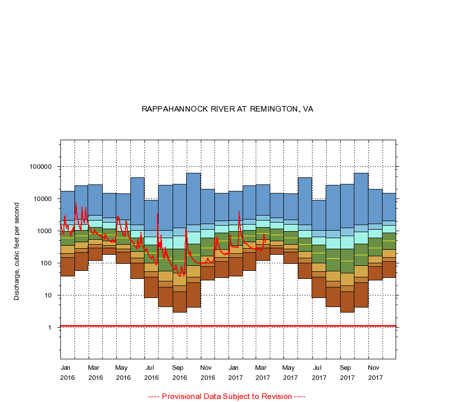
RAPPAHANNOCK RIVER AT REMINGTON, VA
|
Minimum daily flow
|
|
|
5th percentile
|
|
|
|
10th percentile
|
|
|
|
|
25th percentile
|
|
|
|
|
|
Median
|
|
|
|
|
|
|
75th percentile
|
|
|
|
|
|
|
|
90th percentile
|
|
|
|
|
|
|
|
|
95th percentile
|
|
|
|
|
|
|
|
|
|
Maximum daily flow
|
|
|
|
|
|
|
|
|
|
|
|
Years of record
|
January
|
39.0
|
148
|
202
|
356
|
602
|
962
|
1,540
|
2,110
|
17,100
|
|
73
|
February
|
58.0
|
211
|
285
|
450
|
690
|
1,030
|
1,630
|
2,300
|
26,000
|
|
73
|
March
|
120
|
297
|
385
|
548
|
840
|
1,310
|
2,140
|
3,100
|
27,400
|
|
73
|
April
|
182
|
299
|
352
|
490
|
754
|
1,170
|
1,850
|
2,570
|
15,100
|
|
73
|
May
|
98.0
|
222
|
274
|
375
|
609
|
958
|
1,590
|
2,260
|
14,500
|
|
73
|
June
|
33.0
|
99.6
|
143
|
232
|
384
|
612
|
1,050
|
1,570
|
45,800
|
|
73
|
July
|
8.40
|
36.2
|
54.0
|
102
|
209
|
372
|
664
|
1,040
|
8,950
|
|
73
|
August
|
4.30
|
18.0
|
27.0
|
56.0
|
140
|
276
|
597
|
1,040
|
26,800
|
|
73
|
September
|
2.90
|
13.0
|
20.0
|
49.0
|
116
|
272
|
702
|
1,270
|
28,200
|
|
73
|
October
|
4.20
|
25.0
|
37.0
|
83.0
|
177
|
401
|
930
|
1,570
|
64,000
|
|
73
|
November
|
29.0
|
77.0
|
100
|
164
|
296
|
610
|
1,130
|
1,670
|
20,100
|
|
73
|
December
|
35.0
|
112
|
150
|
268
|
487
|
863
|
1,480
|
2,090
|
14,800
|
|
73
|
|
|
Instantaneous minimum flow for period of record =
1.10
cubic feet per second.
The current daily value for 03/22/2017 is 445.0 cubic feet per second.
----
Provisional Data Subject to Revision ----
|