|
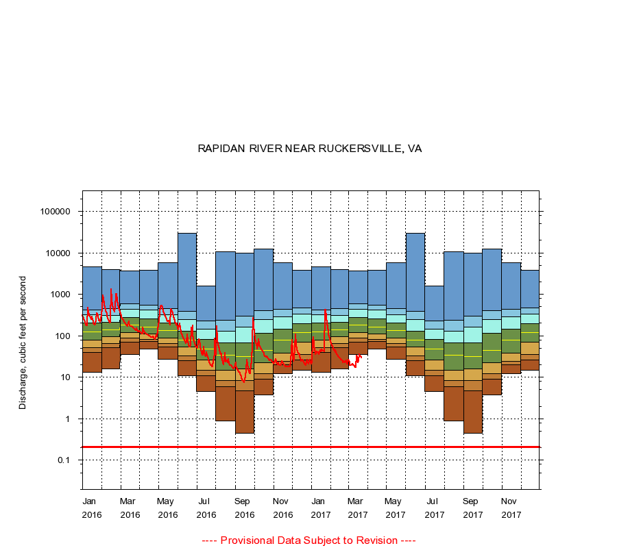
01665500
RAPIDAN RIVER NEAR RUCKERSVILLE, VA
|
Minimum daily flow
|
|
|
5th percentile
|
|
|
|
10th percentile
|
|
|
|
|
25th percentile
|
|
|
|
|
|
Median
|
|
|
|
|
|
|
75th percentile
|
|
|
|
|
|
|
|
90th percentile
|
|
|
|
|
|
|
|
|
95th percentile
|
|
|
|
|
|
|
|
|
|
Maximum daily flow
|
|
|
|
|
|
|
|
|
|
|
|
Years of record
|
January
|
13.0
|
40.0
|
52.0
|
80.0
|
126
|
202
|
323
|
416
|
4,520
|
|
70
|
February
|
16.0
|
51.9
|
64.0
|
94.0
|
138
|
210
|
314
|
445
|
4,010
|
|
70
|
March
|
35.0
|
69.6
|
87.1
|
120
|
178
|
273
|
429
|
595
|
3,640
|
|
70
|
April
|
48.0
|
74.0
|
83.0
|
110
|
160
|
260
|
413
|
550
|
3,830
|
|
70
|
May
|
27.0
|
54.0
|
65.0
|
88.0
|
136
|
206
|
321
|
458
|
5,710
|
|
70
|
June
|
11.0
|
25.0
|
33.0
|
53.0
|
79.0
|
130
|
242
|
387
|
29,400
|
|
70
|
July
|
4.60
|
11.0
|
15.0
|
26.0
|
48.0
|
82.0
|
145
|
226
|
1,570
|
|
69
|
August
|
0.87
|
5.90
|
8.20
|
15.0
|
34.0
|
68.0
|
129
|
236
|
10,600
|
|
69
|
September
|
0.45
|
4.80
|
8.20
|
16.0
|
31.0
|
67.2
|
160
|
300
|
9,810
|
|
69
|
October
|
3.80
|
9.10
|
12.0
|
22.0
|
45.0
|
114
|
246
|
407
|
12,500
|
|
70
|
November
|
12.0
|
20.0
|
24.0
|
38.0
|
79.0
|
146
|
287
|
433
|
5,790
|
|
70
|
December
|
15.0
|
26.0
|
35.0
|
69.0
|
118
|
197
|
339
|
473
|
3,790
|
|
70
|
|
|
Instantaneous minimum flow for period of record =
0.21
cubic feet per second.
The current daily value for 03/22/2017 is 29.0 cubic feet per second.
----
Provisional Data Subject to Revision ----
|