|
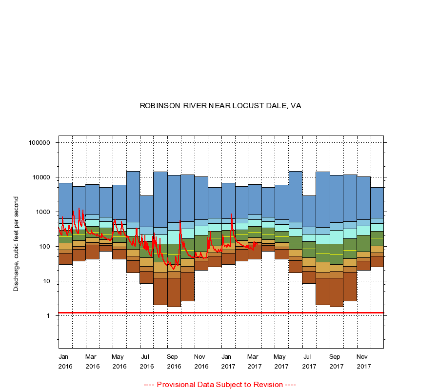
01666500
ROBINSON RIVER NEAR LOCUST DALE, VA
|
Minimum daily flow
|
|
|
5th percentile
|
|
|
|
10th percentile
|
|
|
|
|
25th percentile
|
|
|
|
|
|
Median
|
|
|
|
|
|
|
75th percentile
|
|
|
|
|
|
|
|
90th percentile
|
|
|
|
|
|
|
|
|
95th percentile
|
|
|
|
|
|
|
|
|
|
Maximum daily flow
|
|
|
|
|
|
|
|
|
|
|
|
Years of record
|
January
|
30.0
|
63.0
|
80.0
|
123
|
190
|
292
|
459
|
632
|
6,760
|
|
72
|
February
|
37.0
|
81.0
|
100
|
147
|
214
|
303
|
465
|
661
|
5,350
|
|
72
|
March
|
43.0
|
108
|
129
|
178
|
250
|
375
|
589
|
829
|
6,120
|
|
72
|
April
|
72.0
|
105
|
120
|
157
|
224
|
340
|
525
|
698
|
5,070
|
|
72
|
May
|
42.0
|
82.0
|
95.0
|
127
|
187
|
275
|
421
|
590
|
5,950
|
|
72
|
June
|
17.0
|
39.0
|
52.1
|
82.0
|
126
|
193
|
330
|
503
|
14,700
|
|
72
|
July
|
8.40
|
19.0
|
26.6
|
47.0
|
84.0
|
136
|
226
|
363
|
2,920
|
|
72
|
August
|
2.00
|
12.0
|
18.0
|
35.0
|
64.0
|
116
|
213
|
350
|
14,000
|
|
73
|
September
|
1.80
|
12.0
|
19.0
|
30.0
|
58.0
|
115
|
292
|
481
|
11,400
|
|
73
|
October
|
2.60
|
18.0
|
26.0
|
44.0
|
76.0
|
168
|
323
|
511
|
11,600
|
|
72
|
November
|
20.0
|
38.0
|
47.0
|
70.0
|
117
|
211
|
387
|
589
|
10,400
|
|
72
|
December
|
25.0
|
51.6
|
66.0
|
103
|
170
|
268
|
450
|
651
|
4,970
|
|
72
|
|
|
Instantaneous minimum flow for period of record =
1.20
cubic feet per second.
The current daily value for 03/22/2017 is 113.0 cubic feet per second.
----
Provisional Data Subject to Revision ----
|