|
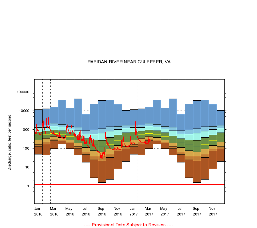
01667500
RAPIDAN RIVER NEAR CULPEPER, VA
|
Minimum daily flow
|
|
|
5th percentile
|
|
|
|
10th percentile
|
|
|
|
|
25th percentile
|
|
|
|
|
|
Median
|
|
|
|
|
|
|
75th percentile
|
|
|
|
|
|
|
|
90th percentile
|
|
|
|
|
|
|
|
|
95th percentile
|
|
|
|
|
|
|
|
|
|
Maximum daily flow
|
|
|
|
|
|
|
|
|
|
|
|
Years of record
|
January
|
47.0
|
123
|
163
|
279
|
460
|
752
|
1,260
|
1,690
|
11,300
|
|
85
|
February
|
44.0
|
168
|
218
|
330
|
530
|
809
|
1,260
|
1,730
|
12,800
|
|
85
|
March
|
94.0
|
250
|
300
|
422
|
608
|
955
|
1,520
|
2,130
|
15,900
|
|
85
|
April
|
167
|
244
|
279
|
377
|
536
|
872
|
1,350
|
1,840
|
38,000
|
|
85
|
May
|
97.0
|
184
|
214
|
285
|
430
|
666
|
1,050
|
1,470
|
14,000
|
|
85
|
June
|
42.0
|
97.0
|
125
|
187
|
283
|
459
|
857
|
1,290
|
43,500
|
|
85
|
July
|
18.0
|
46.0
|
62.0
|
108
|
189
|
320
|
589
|
875
|
6,590
|
|
85
|
August
|
2.70
|
24.8
|
39.0
|
75.0
|
149
|
276
|
566
|
950
|
22,600
|
|
85
|
September
|
1.50
|
21.6
|
39.0
|
65.0
|
131
|
267
|
638
|
1,090
|
34,900
|
|
85
|
October
|
2.20
|
32.0
|
49.0
|
88.0
|
161
|
377
|
809
|
1,400
|
37,900
|
|
85
|
November
|
8.00
|
71.0
|
89.0
|
140
|
256
|
503
|
981
|
1,440
|
22,500
|
|
85
|
December
|
20.0
|
88.0
|
121
|
218
|
392
|
666
|
1,170
|
1,680
|
10,400
|
|
85
|
|
|
Instantaneous minimum flow for period of record =
1.20
cubic feet per second.
The current daily value for 03/22/2017 is 240.0 cubic feet per second.
----
Provisional Data Subject to Revision ----
|