|
01668000
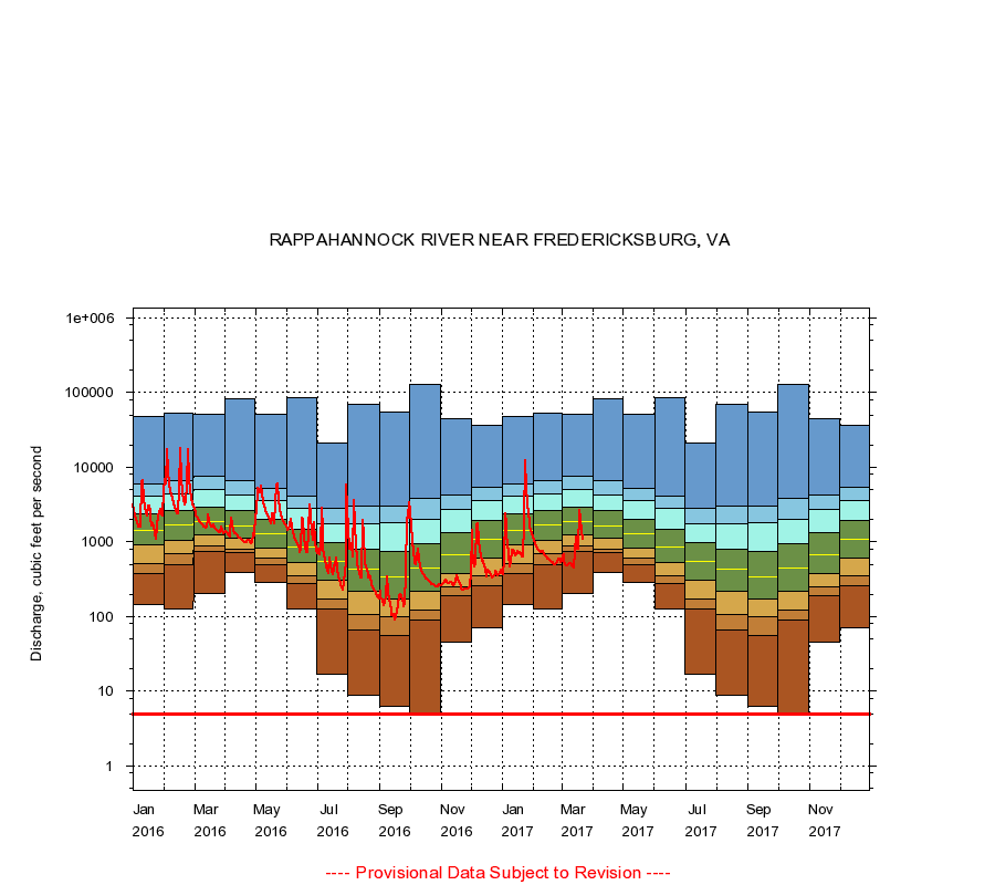
RAPPAHANNOCK RIVER NEAR FREDERICKSBURG, VA
|
Minimum daily flow
|
|
|
5th percentile
|
|
|
|
10th percentile
|
|
|
|
|
25th percentile
|
|
|
|
|
|
Median
|
|
|
|
|
|
|
75th percentile
|
|
|
|
|
|
|
|
90th percentile
|
|
|
|
|
|
|
|
|
95th percentile
|
|
|
|
|
|
|
|
|
|
Maximum daily flow
|
|
|
|
|
|
|
|
|
|
|
|
Years of record
|
January
|
147
|
375
|
510
|
900
|
1,430
|
2,360
|
4,070
|
5,950
|
47,000
|
|
108
|
February
|
126
|
490
|
690
|
1,060
|
1,700
|
2,630
|
4,430
|
6,580
|
52,000
|
|
108
|
March
|
206
|
735
|
888
|
1,250
|
1,840
|
2,920
|
5,040
|
7,500
|
51,500
|
|
108
|
April
|
385
|
708
|
810
|
1,120
|
1,620
|
2,600
|
4,280
|
6,510
|
81,100
|
|
108
|
May
|
283
|
500
|
601
|
832
|
1,270
|
2,020
|
3,540
|
5,170
|
51,000
|
|
108
|
June
|
125
|
277
|
351
|
525
|
858
|
1,470
|
2,770
|
4,140
|
84,200
|
|
108
|
July
|
17.0
|
127
|
174
|
302
|
542
|
964
|
1,770
|
2,850
|
21,400
|
|
108
|
August
|
8.80
|
67.0
|
105
|
215
|
425
|
796
|
1,720
|
2,980
|
68,400
|
|
108
|
September
|
6.20
|
56.0
|
99.0
|
170
|
344
|
744
|
1,780
|
3,020
|
54,600
|
|
108
|
October
|
5.00
|
89.0
|
122
|
221
|
440
|
958
|
2,030
|
3,820
|
127,000
|
|
108
|
November
|
45.0
|
193
|
247
|
382
|
680
|
1,320
|
2,680
|
4,310
|
44,300
|
|
108
|
December
|
70.0
|
260
|
355
|
598
|
1,080
|
1,940
|
3,560
|
5,420
|
36,300
|
|
108
|
|
|
Instantaneous minimum flow for period of record =
5.00
cubic feet per second.
The current daily value for 03/22/2017 is 1080.0 cubic feet per second.
----
Provisional Data Subject to Revision ----
|