|
01671100
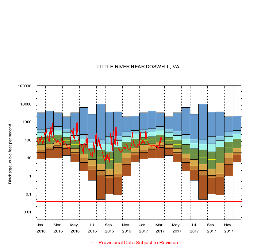
LITTLE RIVER NEAR DOSWELL, VA
|
Minimum daily flow
|
|
|
5th percentile
|
|
|
|
10th percentile
|
|
|
|
|
25th percentile
|
|
|
|
|
|
Median
|
|
|
|
|
|
|
75th percentile
|
|
|
|
|
|
|
|
90th percentile
|
|
|
|
|
|
|
|
|
95th percentile
|
|
|
|
|
|
|
|
|
|
Maximum daily flow
|
|
|
|
|
|
|
|
|
|
|
|
Years of record
|
January
|
8.90
|
20.2
|
27.0
|
55.0
|
90.0
|
142
|
254
|
394
|
3,270
|
|
53
|
February
|
9.90
|
30.0
|
37.0
|
61.2
|
104
|
152
|
280
|
427
|
3,970
|
|
53
|
March
|
9.70
|
39.0
|
50.4
|
75.0
|
112
|
183
|
352
|
550
|
3,320
|
|
53
|
April
|
14.0
|
35.0
|
41.1
|
58.0
|
90.0
|
142
|
252
|
416
|
1,970
|
|
53
|
May
|
6.00
|
17.0
|
21.0
|
35.0
|
58.0
|
101
|
182
|
310
|
3,220
|
|
53
|
June
|
1.90
|
5.70
|
9.60
|
17.0
|
32.0
|
58.0
|
116
|
204
|
6,410
|
|
53
|
July
|
0.58
|
2.20
|
3.70
|
8.50
|
16.0
|
33.0
|
67.6
|
112
|
2,680
|
|
53
|
August
|
0.05
|
1.02
|
2.00
|
4.60
|
11.0
|
27.0
|
59.6
|
103
|
9,800
|
|
53
|
September
|
0.10
|
0.80
|
1.10
|
2.50
|
8.40
|
22.0
|
62.0
|
157
|
3,550
|
|
53
|
October
|
0.09
|
0.90
|
1.34
|
5.20
|
16.0
|
41.0
|
96.0
|
168
|
3,700
|
|
53
|
November
|
1.00
|
4.36
|
9.61
|
19.0
|
37.0
|
78.0
|
157
|
282
|
1,930
|
|
53
|
December
|
5.80
|
15.0
|
20.0
|
36.0
|
69.0
|
116
|
220
|
335
|
2,090
|
|
53
|
|
|
Instantaneous minimum flow for period of record =
0.04
cubic feet per second.
The current daily value for 03/22/2017 is 100.0 cubic feet per second.
----
Provisional Data Subject to Revision ----
|