|
01672500
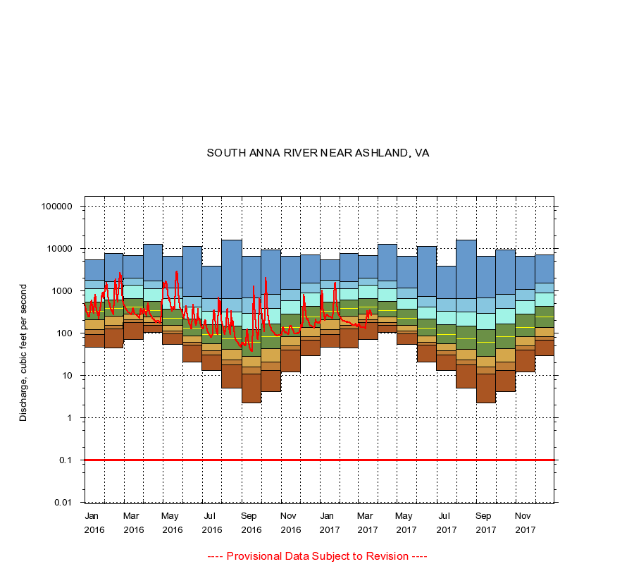
SOUTH ANNA RIVER NEAR ASHLAND, VA
|
Minimum daily flow
|
|
|
5th percentile
|
|
|
|
10th percentile
|
|
|
|
|
25th percentile
|
|
|
|
|
|
Median
|
|
|
|
|
|
|
75th percentile
|
|
|
|
|
|
|
|
90th percentile
|
|
|
|
|
|
|
|
|
95th percentile
|
|
|
|
|
|
|
|
|
|
Maximum daily flow
|
|
|
|
|
|
|
|
|
|
|
|
Years of record
|
January
|
46.0
|
94.0
|
121
|
210
|
329
|
539
|
1,130
|
1,810
|
5,360
|
|
79
|
February
|
45.0
|
125
|
154
|
248
|
382
|
616
|
1,120
|
1,640
|
7,560
|
|
79
|
March
|
70.0
|
175
|
207
|
284
|
422
|
669
|
1,370
|
1,960
|
6,720
|
|
79
|
April
|
103
|
153
|
175
|
240
|
346
|
569
|
1,130
|
1,730
|
12,800
|
|
79
|
May
|
54.0
|
97.0
|
113
|
155
|
226
|
366
|
664
|
1,180
|
6,650
|
|
79
|
June
|
21.0
|
52.0
|
62.0
|
86.0
|
132
|
220
|
414
|
727
|
11,100
|
|
79
|
July
|
13.0
|
31.0
|
38.0
|
56.0
|
92.0
|
156
|
329
|
659
|
3,880
|
|
80
|
August
|
5.00
|
18.0
|
23.0
|
41.0
|
74.0
|
146
|
323
|
660
|
16,000
|
|
80
|
September
|
2.30
|
11.0
|
16.0
|
28.0
|
62.0
|
120
|
289
|
681
|
6,510
|
|
80
|
October
|
4.10
|
13.0
|
21.0
|
44.0
|
84.0
|
166
|
388
|
835
|
9,300
|
|
79
|
November
|
12.0
|
40.6
|
51.0
|
83.0
|
137
|
280
|
591
|
1,100
|
6,520
|
|
79
|
December
|
30.0
|
69.0
|
83.0
|
137
|
238
|
425
|
899
|
1,500
|
7,170
|
|
79
|
|
|
Instantaneous minimum flow for period of record =
0.10
cubic feet per second.
The current daily value for 03/22/2017 is 261.0 cubic feet per second.
----
Provisional Data Subject to Revision ----
|