|
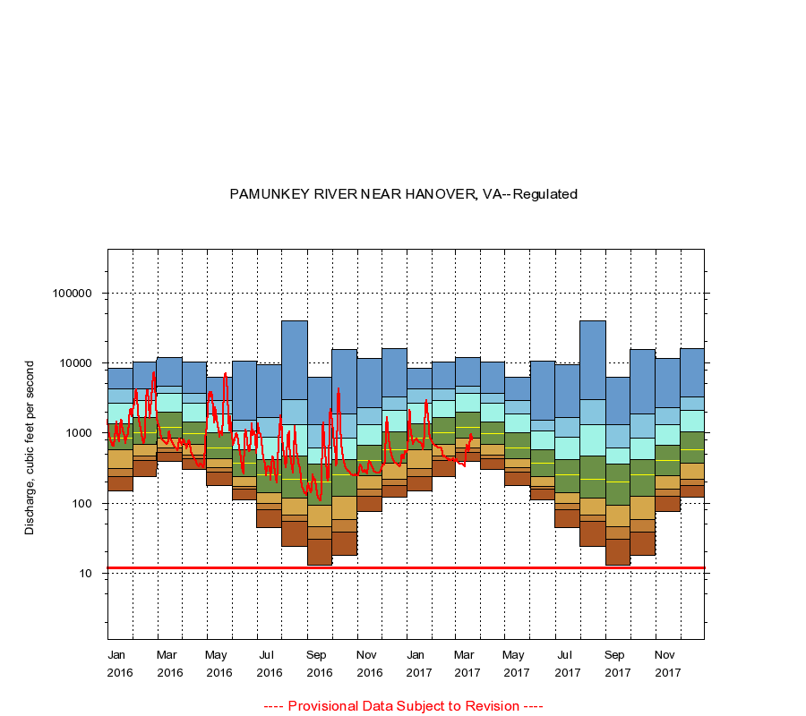
01673000
PAMUNKEY RIVER NEAR HANOVER, VA
|
Minimum daily flow
|
|
|
5th percentile
|
|
|
|
10th percentile
|
|
|
|
|
25th percentile
|
|
|
|
|
|
Median
|
|
|
|
|
|
|
75th percentile
|
|
|
|
|
|
|
|
90th percentile
|
|
|
|
|
|
|
|
|
95th percentile
|
|
|
|
|
|
|
|
|
|
Maximum daily flow
|
|
|
|
|
|
|
|
|
|
|
|
Years of record
|
January
|
150
|
239
|
313
|
570
|
850
|
1,370
|
2,660
|
4,210
|
8,430
|
|
30
|
February
|
237
|
406
|
465
|
685
|
1,020
|
1,670
|
2,930
|
4,280
|
10,400
|
|
30
|
March
|
393
|
531
|
619
|
855
|
1,210
|
1,970
|
3,660
|
4,700
|
12,000
|
|
30
|
April
|
303
|
429
|
487
|
685
|
971
|
1,430
|
2,620
|
3,640
|
10,400
|
|
30
|
May
|
177
|
278
|
321
|
429
|
619
|
1,000
|
1,890
|
2,890
|
6,300
|
|
30
|
June
|
111
|
156
|
172
|
237
|
375
|
580
|
1,060
|
1,540
|
10,700
|
|
30
|
July
|
44.0
|
81.0
|
99.0
|
142
|
252
|
422
|
880
|
1,680
|
9,530
|
|
30
|
August
|
24.0
|
54.0
|
68.2
|
117
|
221
|
465
|
1,330
|
2,960
|
39,300
|
|
30
|
September
|
13.0
|
30.0
|
46.0
|
92.0
|
199
|
356
|
607
|
1,320
|
6,220
|
|
30
|
October
|
18.0
|
38.1
|
58.2
|
125
|
253
|
422
|
842
|
1,860
|
15,600
|
|
31
|
November
|
75.0
|
123
|
156
|
243
|
404
|
676
|
1,300
|
2,290
|
11,500
|
|
31
|
December
|
120
|
177
|
221
|
370
|
580
|
1,030
|
2,100
|
3,310
|
15,800
|
|
31
|
|
|
Instantaneous minimum flow for period of record =
12.0
cubic feet per second.
The current daily value for 03/22/2017 is 801.0 cubic feet per second.
----
Provisional Data Subject to Revision ----
|