|
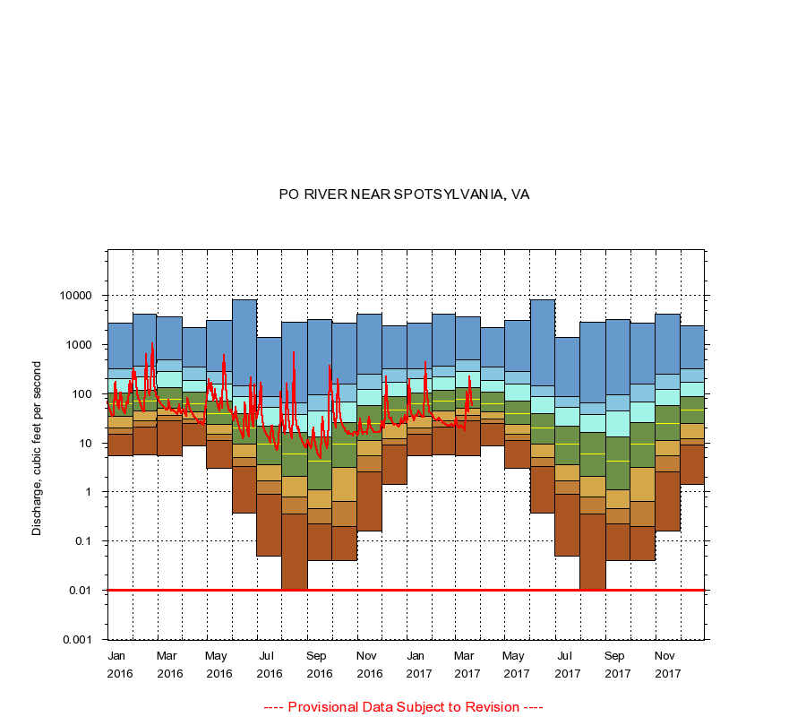
01673800
PO RIVER NEAR SPOTSYLVANIA, VA
|
Minimum daily flow
|
|
|
5th percentile
|
|
|
|
10th percentile
|
|
|
|
|
25th percentile
|
|
|
|
|
|
Median
|
|
|
|
|
|
|
75th percentile
|
|
|
|
|
|
|
|
90th percentile
|
|
|
|
|
|
|
|
|
95th percentile
|
|
|
|
|
|
|
|
|
|
Maximum daily flow
|
|
|
|
|
|
|
|
|
|
|
|
Years of record
|
January
|
5.40
|
15.0
|
20.0
|
35.0
|
62.0
|
105
|
202
|
328
|
2,710
|
|
53
|
February
|
5.70
|
21.0
|
28.0
|
45.0
|
71.0
|
116
|
222
|
370
|
4,130
|
|
53
|
March
|
5.40
|
28.0
|
36.0
|
50.0
|
78.0
|
135
|
284
|
498
|
3,680
|
|
53
|
April
|
8.50
|
25.0
|
30.0
|
42.0
|
63.0
|
109
|
188
|
348
|
2,280
|
|
53
|
May
|
3.00
|
11.0
|
15.0
|
24.0
|
39.0
|
72.0
|
160
|
281
|
3,070
|
|
53
|
June
|
0.37
|
3.30
|
5.10
|
9.40
|
20.0
|
39.0
|
86.0
|
144
|
8,160
|
|
53
|
July
|
0.05
|
0.90
|
1.70
|
3.60
|
9.30
|
22.0
|
53.0
|
89.0
|
1,400
|
|
53
|
August
|
0.00
|
0.35
|
0.78
|
2.10
|
5.90
|
16.0
|
37.0
|
65.8
|
2,870
|
|
53
|
September
|
0.04
|
0.22
|
0.46
|
1.10
|
4.20
|
13.0
|
44.8
|
96.4
|
3,330
|
|
53
|
October
|
0.04
|
0.20
|
0.64
|
3.10
|
9.50
|
26.0
|
68.0
|
160
|
2,780
|
|
53
|
November
|
0.16
|
2.56
|
5.50
|
11.0
|
24.5
|
58.0
|
125
|
251
|
4,210
|
|
53
|
December
|
1.40
|
9.20
|
12.0
|
25.0
|
47.0
|
87.0
|
174
|
318
|
2,480
|
|
53
|
|
|
Instantaneous minimum flow for period of record =
0.00
cubic feet per second.
Flow values of 0.00 are plotted as 0.01
The current daily value for 03/22/2017 is 57.0 cubic feet per second.
----
Provisional Data Subject to Revision ----
|