|
02013000
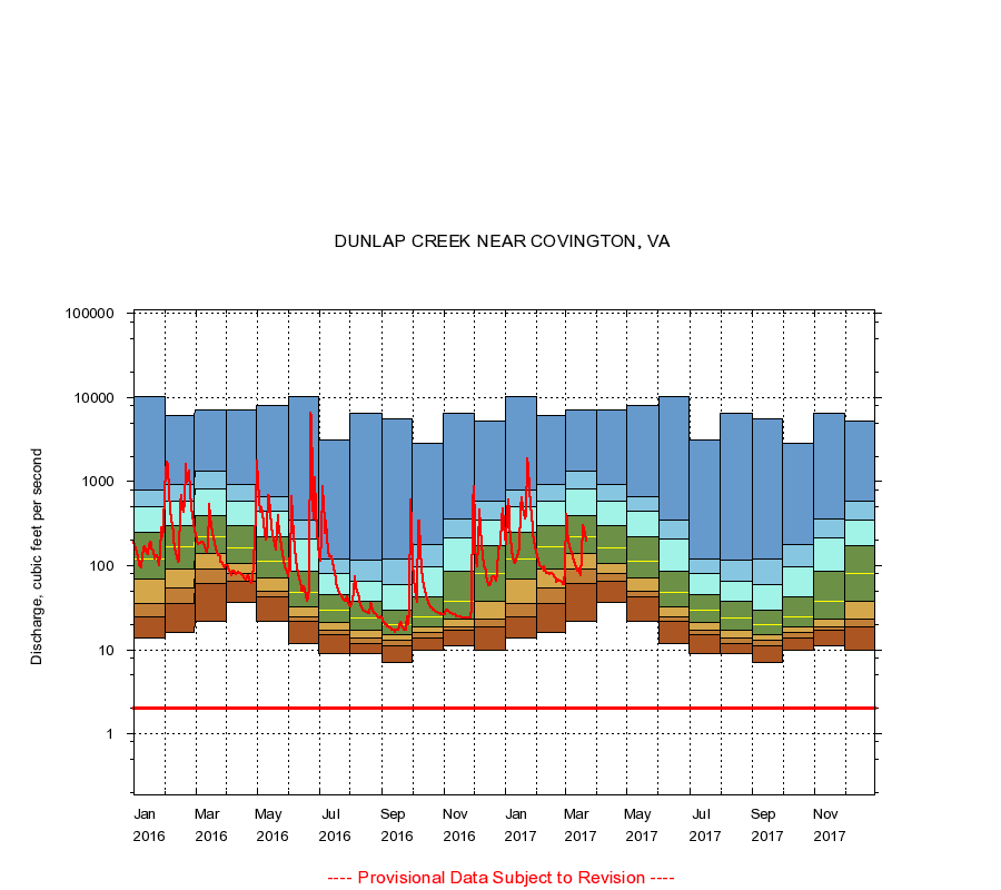
DUNLAP CREEK NEAR COVINGTON, VA
|
Minimum daily flow
|
|
|
5th percentile
|
|
|
|
10th percentile
|
|
|
|
|
25th percentile
|
|
|
|
|
|
Median
|
|
|
|
|
|
|
75th percentile
|
|
|
|
|
|
|
|
90th percentile
|
|
|
|
|
|
|
|
|
95th percentile
|
|
|
|
|
|
|
|
|
|
Maximum daily flow
|
|
|
|
|
|
|
|
|
|
|
|
Years of record
|
January
|
14.0
|
25.0
|
36.0
|
70.0
|
120
|
246
|
502
|
800
|
10,400
|
|
87
|
February
|
16.0
|
36.0
|
54.0
|
91.0
|
168
|
304
|
582
|
913
|
6,080
|
|
87
|
March
|
22.0
|
61.9
|
90.0
|
138
|
218
|
392
|
818
|
1,340
|
7,020
|
|
87
|
April
|
37.0
|
65.6
|
80.0
|
106
|
162
|
298
|
579
|
919
|
7,100
|
|
87
|
May
|
22.0
|
43.0
|
50.0
|
72.0
|
114
|
222
|
439
|
668
|
8,090
|
|
87
|
June
|
12.0
|
22.0
|
25.0
|
32.0
|
48.0
|
87.0
|
208
|
351
|
10,200
|
|
87
|
July
|
9.10
|
15.0
|
17.0
|
21.0
|
30.0
|
45.0
|
80.0
|
120
|
3,100
|
|
87
|
August
|
9.00
|
12.0
|
14.0
|
17.0
|
24.0
|
38.0
|
66.0
|
117
|
6,420
|
|
87
|
September
|
7.00
|
11.0
|
13.0
|
15.0
|
20.0
|
30.0
|
59.0
|
121
|
5,560
|
|
87
|
October
|
10.0
|
14.0
|
16.0
|
19.0
|
25.0
|
43.0
|
97.2
|
180
|
2,900
|
|
87
|
November
|
11.0
|
17.0
|
19.0
|
23.0
|
38.0
|
87.0
|
213
|
363
|
6,460
|
|
87
|
December
|
10.0
|
19.0
|
23.0
|
37.5
|
80.0
|
172
|
350
|
591
|
5,270
|
|
87
|
|
|
Instantaneous minimum flow for period of record =
2.00
cubic feet per second.
The current daily value for 03/22/2017 is 194.0 cubic feet per second.
----
Provisional Data Subject to Revision ----
|