|
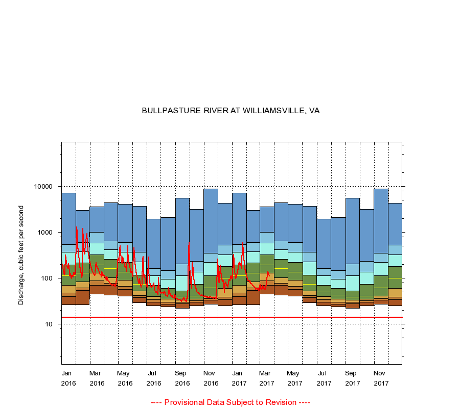
02015700
BULLPASTURE RIVER AT WILLIAMSVILLE, VA
|
Minimum daily flow
|
|
|
5th percentile
|
|
|
|
10th percentile
|
|
|
|
|
25th percentile
|
|
|
|
|
|
Median
|
|
|
|
|
|
|
75th percentile
|
|
|
|
|
|
|
|
90th percentile
|
|
|
|
|
|
|
|
|
95th percentile
|
|
|
|
|
|
|
|
|
|
Maximum daily flow
|
|
|
|
|
|
|
|
|
|
|
|
Years of record
|
January
|
26.0
|
40.0
|
48.0
|
70.0
|
114
|
195
|
363
|
533
|
7,200
|
|
55
|
February
|
26.0
|
54.0
|
62.0
|
84.0
|
130
|
216
|
377
|
601
|
3,030
|
|
55
|
March
|
45.0
|
69.0
|
88.0
|
130
|
193
|
325
|
577
|
985
|
3,600
|
|
55
|
April
|
43.0
|
69.0
|
77.0
|
101
|
160
|
255
|
420
|
637
|
4,360
|
|
55
|
May
|
41.0
|
57.0
|
66.0
|
91.0
|
134
|
221
|
366
|
595
|
4,110
|
|
55
|
June
|
29.0
|
38.0
|
42.0
|
53.0
|
73.0
|
116
|
223
|
371
|
3,650
|
|
55
|
July
|
25.0
|
30.0
|
34.0
|
40.0
|
50.0
|
69.0
|
112
|
164
|
1,940
|
|
55
|
August
|
24.0
|
27.0
|
30.0
|
35.0
|
43.0
|
59.8
|
95.0
|
145
|
2,120
|
|
56
|
September
|
22.0
|
28.0
|
30.0
|
33.0
|
39.0
|
52.0
|
113
|
202
|
5,600
|
|
56
|
October
|
25.0
|
30.0
|
32.0
|
35.0
|
41.0
|
74.0
|
136
|
232
|
3,150
|
|
55
|
November
|
27.0
|
33.0
|
36.0
|
41.0
|
61.5
|
114
|
222
|
351
|
8,700
|
|
55
|
December
|
25.0
|
34.0
|
39.0
|
60.0
|
99.0
|
178
|
321
|
527
|
4,260
|
|
55
|
|
|
Instantaneous minimum flow for period of record =
14.0
cubic feet per second.
The current daily value for 03/22/2017 is 111.0 cubic feet per second.
----
Provisional Data Subject to Revision ----
|