|
02017500
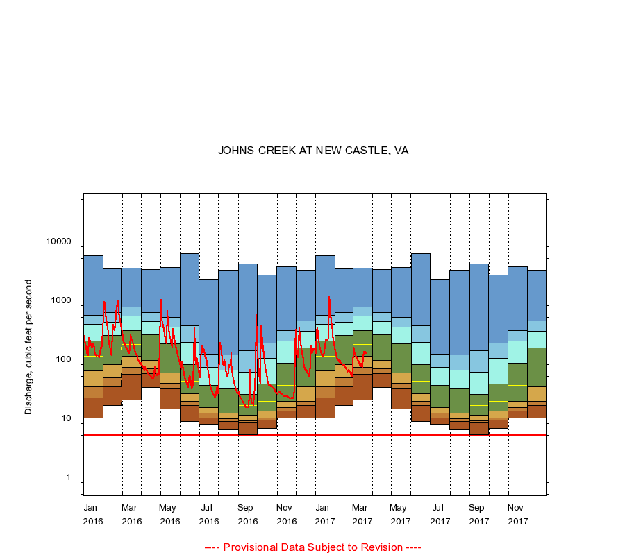
JOHNS CREEK AT NEW CASTLE, VA
|
Minimum daily flow
|
|
|
5th percentile
|
|
|
|
10th percentile
|
|
|
|
|
25th percentile
|
|
|
|
|
|
Median
|
|
|
|
|
|
|
75th percentile
|
|
|
|
|
|
|
|
90th percentile
|
|
|
|
|
|
|
|
|
95th percentile
|
|
|
|
|
|
|
|
|
|
Maximum daily flow
|
|
|
|
|
|
|
|
|
|
|
|
Years of record
|
January
|
10.0
|
22.0
|
34.0
|
62.0
|
110
|
201
|
384
|
552
|
5,690
|
|
89
|
February
|
16.0
|
34.0
|
48.0
|
81.0
|
142
|
247
|
417
|
603
|
3,380
|
|
89
|
March
|
20.0
|
55.0
|
71.0
|
112
|
176
|
299
|
530
|
766
|
3,460
|
|
89
|
April
|
33.0
|
56.0
|
68.0
|
93.0
|
143
|
255
|
434
|
617
|
3,240
|
|
89
|
May
|
14.0
|
31.0
|
39.0
|
58.0
|
100
|
181
|
346
|
499
|
3,570
|
|
89
|
June
|
8.80
|
16.0
|
19.0
|
26.0
|
42.0
|
80.0
|
192
|
362
|
6,040
|
|
89
|
July
|
7.80
|
10.0
|
12.0
|
15.0
|
22.0
|
36.0
|
72.0
|
121
|
2,210
|
|
89
|
August
|
6.20
|
8.60
|
9.70
|
12.0
|
17.0
|
31.0
|
65.0
|
116
|
3,150
|
|
89
|
September
|
5.20
|
8.20
|
9.00
|
11.0
|
16.0
|
25.0
|
59.0
|
138
|
4,060
|
|
89
|
October
|
6.60
|
9.10
|
10.0
|
13.0
|
19.0
|
37.0
|
102
|
184
|
2,610
|
|
89
|
November
|
10.0
|
13.0
|
15.0
|
19.0
|
36.0
|
85.0
|
200
|
305
|
3,640
|
|
89
|
December
|
10.0
|
16.0
|
19.0
|
34.0
|
75.0
|
153
|
296
|
440
|
3,170
|
|
89
|
|
|
Instantaneous minimum flow for period of record =
5.10
cubic feet per second.
The current daily value for 03/22/2017 is 123.0 cubic feet per second.
----
Provisional Data Subject to Revision ----
|