|
02029000
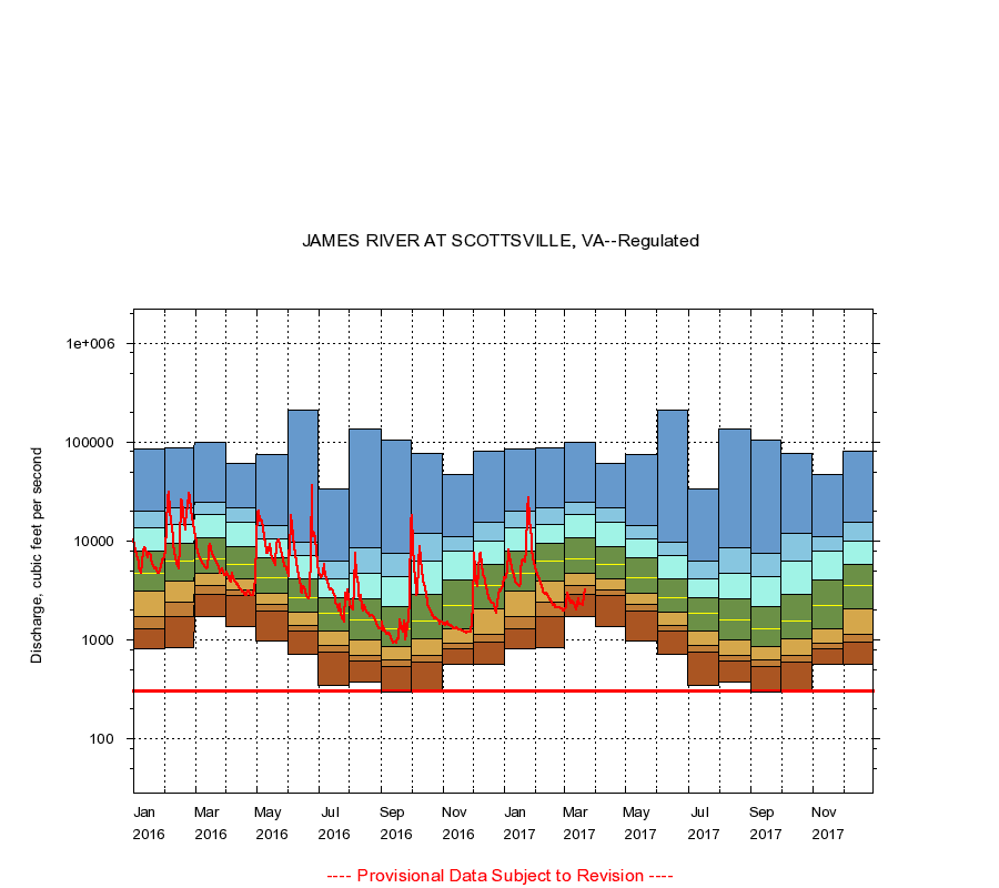
JAMES RIVER AT SCOTTSVILLE, VA
|
Minimum daily flow
|
|
|
5th percentile
|
|
|
|
10th percentile
|
|
|
|
|
25th percentile
|
|
|
|
|
|
Median
|
|
|
|
|
|
|
75th percentile
|
|
|
|
|
|
|
|
90th percentile
|
|
|
|
|
|
|
|
|
95th percentile
|
|
|
|
|
|
|
|
|
|
Maximum daily flow
|
|
|
|
|
|
|
|
|
|
|
|
Years of record
|
January
|
804
|
1,300
|
1,740
|
3,140
|
4,770
|
7,930
|
13,500
|
19,800
|
85,100
|
|
55
|
February
|
830
|
1,700
|
2,400
|
3,900
|
6,220
|
9,480
|
14,700
|
21,900
|
86,700
|
|
55
|
March
|
1,720
|
2,920
|
3,520
|
4,680
|
6,600
|
10,900
|
18,500
|
24,700
|
99,400
|
|
55
|
April
|
1,370
|
2,780
|
3,180
|
4,190
|
5,780
|
8,870
|
15,600
|
21,400
|
60,900
|
|
55
|
May
|
970
|
1,960
|
2,260
|
2,940
|
4,260
|
6,720
|
10,600
|
14,300
|
75,400
|
|
55
|
June
|
708
|
1,220
|
1,380
|
1,890
|
2,700
|
4,160
|
7,060
|
9,680
|
208,000
|
|
55
|
July
|
350
|
752
|
872
|
1,220
|
1,880
|
2,700
|
4,090
|
6,230
|
34,000
|
|
55
|
August
|
370
|
607
|
696
|
992
|
1,600
|
2,600
|
4,760
|
8,590
|
135,000
|
|
55
|
September
|
300
|
542
|
625
|
850
|
1,300
|
2,180
|
4,410
|
7,530
|
105,000
|
|
55
|
October
|
307
|
589
|
700
|
1,030
|
1,560
|
2,900
|
6,220
|
11,800
|
77,200
|
|
56
|
November
|
560
|
807
|
919
|
1,310
|
2,200
|
4,050
|
7,840
|
11,000
|
46,700
|
|
56
|
December
|
570
|
952
|
1,140
|
2,050
|
3,500
|
5,800
|
9,970
|
15,600
|
81,600
|
|
55
|
|
|
Instantaneous minimum flow for period of record =
302
cubic feet per second.
The current daily value for 03/22/2017 is 3180.0 cubic feet per second.
----
Provisional Data Subject to Revision ----
|