|
02037500
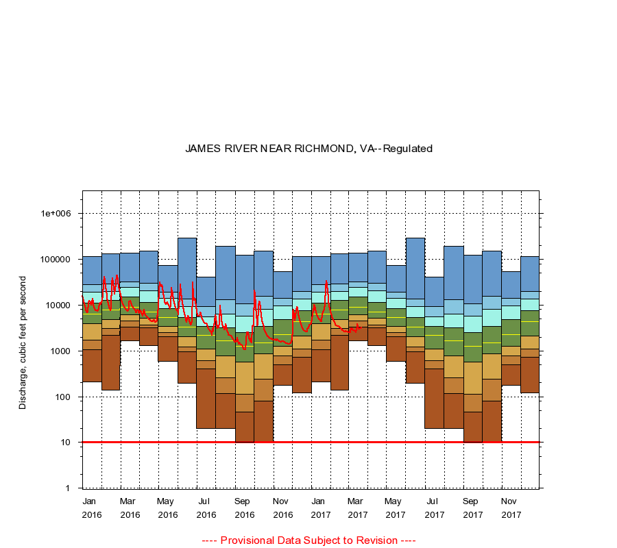
JAMES RIVER NEAR RICHMOND, VA
|
Minimum daily flow
|
|
|
5th percentile
|
|
|
|
10th percentile
|
|
|
|
|
25th percentile
|
|
|
|
|
|
Median
|
|
|
|
|
|
|
75th percentile
|
|
|
|
|
|
|
|
90th percentile
|
|
|
|
|
|
|
|
|
95th percentile
|
|
|
|
|
|
|
|
|
|
Maximum daily flow
|
|
|
|
|
|
|
|
|
|
|
|
Years of record
|
January
|
210
|
1,080
|
1,700
|
3,970
|
6,290
|
11,000
|
18,900
|
28,100
|
117,000
|
|
48
|
February
|
140
|
2,200
|
3,130
|
4,880
|
7,900
|
12,700
|
19,700
|
28,700
|
134,000
|
|
48
|
March
|
1,670
|
3,310
|
4,570
|
6,180
|
9,120
|
15,000
|
24,800
|
32,300
|
136,000
|
|
48
|
April
|
1,300
|
3,200
|
3,700
|
5,120
|
7,160
|
11,500
|
20,500
|
30,400
|
152,000
|
|
48
|
May
|
590
|
2,040
|
2,520
|
3,410
|
5,300
|
8,380
|
14,300
|
19,000
|
74,300
|
|
48
|
June
|
194
|
967
|
1,240
|
2,060
|
3,280
|
5,350
|
9,290
|
13,500
|
296,000
|
|
47
|
July
|
20.0
|
398
|
610
|
1,100
|
2,160
|
3,380
|
5,510
|
9,280
|
41,300
|
|
47
|
August
|
20.0
|
118
|
256
|
775
|
1,650
|
3,200
|
6,480
|
13,000
|
195,000
|
|
47
|
September
|
10.0
|
46.0
|
112
|
570
|
1,280
|
2,520
|
5,740
|
10,600
|
125,000
|
|
47
|
October
|
10.0
|
80.2
|
243
|
850
|
1,500
|
3,400
|
8,210
|
15,600
|
152,000
|
|
48
|
November
|
174
|
491
|
775
|
1,280
|
2,250
|
4,900
|
9,690
|
14,300
|
54,000
|
|
48
|
December
|
123
|
720
|
1,100
|
2,140
|
4,420
|
7,530
|
13,500
|
19,900
|
116,000
|
|
48
|
|
|
Instantaneous minimum flow for period of record =
10.0
cubic feet per second.
The current daily value for 03/22/2017 is 3190.0 cubic feet per second.
----
Provisional Data Subject to Revision ----
|