|
02039000
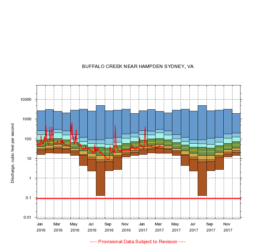
BUFFALO CREEK NEAR HAMPDEN SYDNEY, VA
|
Minimum daily flow
|
|
|
5th percentile
|
|
|
|
10th percentile
|
|
|
|
|
25th percentile
|
|
|
|
|
|
Median
|
|
|
|
|
|
|
75th percentile
|
|
|
|
|
|
|
|
90th percentile
|
|
|
|
|
|
|
|
|
95th percentile
|
|
|
|
|
|
|
|
|
|
Maximum daily flow
|
|
|
|
|
|
|
|
|
|
|
|
Years of record
|
January
|
16.0
|
27.0
|
31.0
|
40.0
|
55.0
|
86.0
|
161
|
263
|
2,640
|
|
69
|
February
|
19.0
|
29.5
|
34.0
|
46.0
|
65.0
|
97.0
|
158
|
244
|
3,040
|
|
69
|
March
|
18.0
|
33.0
|
39.0
|
52.0
|
69.0
|
102
|
200
|
305
|
2,520
|
|
69
|
April
|
18.0
|
29.0
|
33.0
|
43.0
|
60.0
|
87.0
|
156
|
251
|
2,080
|
|
69
|
May
|
14.0
|
22.0
|
25.0
|
33.0
|
47.0
|
64.0
|
100
|
165
|
2,870
|
|
69
|
June
|
4.30
|
14.0
|
16.0
|
24.0
|
35.0
|
48.0
|
71.9
|
116
|
3,220
|
|
69
|
July
|
2.30
|
9.40
|
12.0
|
18.0
|
26.0
|
38.0
|
57.0
|
87.0
|
2,540
|
|
69
|
August
|
0.13
|
6.70
|
8.60
|
14.0
|
22.0
|
37.0
|
55.0
|
88.0
|
4,940
|
|
69
|
September
|
2.40
|
6.90
|
8.60
|
14.0
|
22.0
|
34.0
|
52.0
|
105
|
2,700
|
|
69
|
October
|
2.70
|
12.0
|
14.0
|
20.0
|
30.0
|
44.0
|
67.0
|
118
|
2,920
|
|
69
|
November
|
12.0
|
17.0
|
21.0
|
28.0
|
38.0
|
57.0
|
106
|
172
|
3,240
|
|
69
|
December
|
14.0
|
20.0
|
25.0
|
34.0
|
48.0
|
72.0
|
121
|
198
|
1,970
|
|
69
|
|
|
Instantaneous minimum flow for period of record =
0.09
cubic feet per second.
The current daily value for 03/22/2017 is 37.0 cubic feet per second.
----
Provisional Data Subject to Revision ----
|