|
02040000
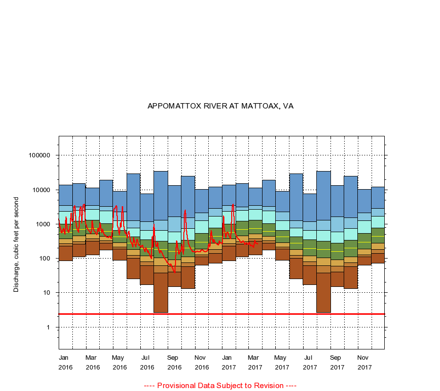
APPOMATTOX RIVER AT MATTOAX, VA
|
Minimum daily flow
|
|
|
5th percentile
|
|
|
|
10th percentile
|
|
|
|
|
25th percentile
|
|
|
|
|
|
Median
|
|
|
|
|
|
|
75th percentile
|
|
|
|
|
|
|
|
90th percentile
|
|
|
|
|
|
|
|
|
95th percentile
|
|
|
|
|
|
|
|
|
|
Maximum daily flow
|
|
|
|
|
|
|
|
|
|
|
|
Years of record
|
January
|
85.0
|
225
|
266
|
372
|
574
|
997
|
2,340
|
3,480
|
13,900
|
|
89
|
February
|
111
|
258
|
306
|
455
|
704
|
1,220
|
2,460
|
3,150
|
15,000
|
|
89
|
March
|
128
|
320
|
378
|
525
|
753
|
1,300
|
2,670
|
3,490
|
11,200
|
|
89
|
April
|
176
|
276
|
326
|
434
|
612
|
1,040
|
2,390
|
3,200
|
18,800
|
|
90
|
May
|
88.0
|
188
|
216
|
291
|
430
|
645
|
1,240
|
2,270
|
9,000
|
|
90
|
June
|
25.0
|
101
|
124
|
182
|
277
|
430
|
775
|
1,240
|
29,600
|
|
90
|
July
|
17.0
|
62.0
|
80.0
|
120
|
192
|
350
|
660
|
1,180
|
7,670
|
|
90
|
August
|
2.60
|
38.0
|
61.0
|
104
|
181
|
318
|
642
|
1,300
|
34,300
|
|
90
|
September
|
15.0
|
40.0
|
60.0
|
90.0
|
157
|
277
|
588
|
1,610
|
13,400
|
|
90
|
October
|
13.0
|
57.0
|
75.0
|
112
|
200
|
337
|
740
|
1,530
|
25,200
|
|
89
|
November
|
64.0
|
110
|
127
|
188
|
294
|
534
|
1,260
|
2,150
|
10,200
|
|
89
|
December
|
72.0
|
141
|
182
|
278
|
445
|
766
|
1,670
|
2,890
|
11,900
|
|
89
|
|
|
Instantaneous minimum flow for period of record =
2.40
cubic feet per second.
The current daily value for 03/22/2017 is 258.0 cubic feet per second.
----
Provisional Data Subject to Revision ----
|