|
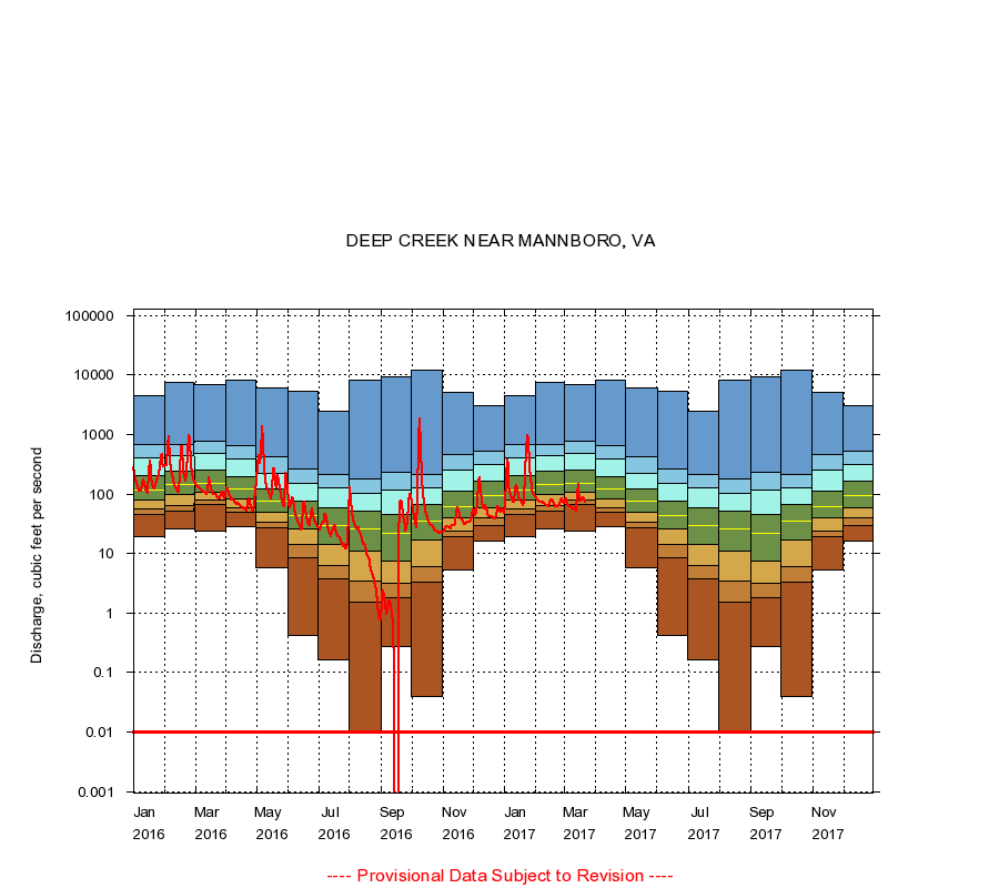
02041000
DEEP CREEK NEAR MANNBORO, VA
|
Minimum daily flow
|
|
|
5th percentile
|
|
|
|
10th percentile
|
|
|
|
|
25th percentile
|
|
|
|
|
|
Median
|
|
|
|
|
|
|
75th percentile
|
|
|
|
|
|
|
|
90th percentile
|
|
|
|
|
|
|
|
|
95th percentile
|
|
|
|
|
|
|
|
|
|
Maximum daily flow
|
|
|
|
|
|
|
|
|
|
|
|
Years of record
|
January
|
19.0
|
45.0
|
55.0
|
79.0
|
117
|
199
|
404
|
670
|
4,400
|
|
69
|
February
|
26.0
|
52.0
|
64.0
|
97.0
|
147
|
240
|
441
|
682
|
7,410
|
|
69
|
March
|
24.0
|
66.0
|
78.0
|
106
|
152
|
251
|
488
|
774
|
6,930
|
|
69
|
April
|
28.0
|
50.0
|
59.0
|
82.0
|
119
|
197
|
387
|
644
|
8,180
|
|
69
|
May
|
5.70
|
27.0
|
34.0
|
49.0
|
76.0
|
123
|
221
|
418
|
6,020
|
|
69
|
June
|
0.42
|
8.50
|
14.0
|
26.0
|
44.0
|
76.0
|
152
|
258
|
5,240
|
|
69
|
July
|
0.16
|
3.80
|
6.30
|
14.0
|
30.0
|
58.0
|
128
|
214
|
2,470
|
|
69
|
August
|
0.00
|
1.50
|
3.50
|
11.0
|
26.0
|
51.0
|
104
|
178
|
8,100
|
|
69
|
September
|
0.27
|
1.80
|
3.10
|
7.50
|
22.0
|
45.0
|
116
|
233
|
9,100
|
|
69
|
October
|
0.04
|
3.30
|
6.00
|
17.0
|
35.0
|
67.0
|
128
|
212
|
12,000
|
|
69
|
November
|
5.30
|
19.0
|
24.0
|
39.0
|
62.0
|
113
|
254
|
462
|
5,160
|
|
69
|
December
|
16.0
|
30.0
|
39.0
|
59.0
|
94.0
|
164
|
306
|
516
|
3,000
|
|
69
|
|
|
Instantaneous minimum flow for period of record =
0.00
cubic feet per second.
Flow values of 0.00 are plotted as 0.01
The current daily value for 03/22/2017 is 74.0 cubic feet per second.
----
Provisional Data Subject to Revision ----
|