|
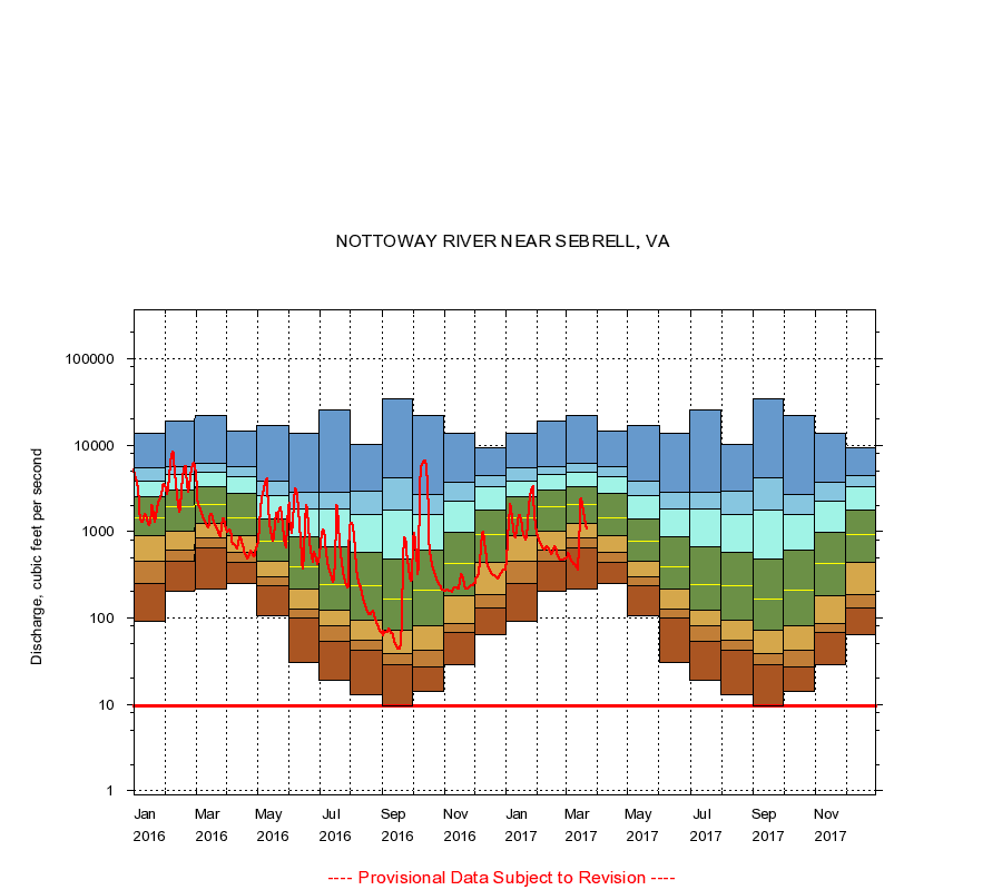
02047000
NOTTOWAY RIVER NEAR SEBRELL, VA
|
Minimum daily flow
|
|
|
5th percentile
|
|
|
|
10th percentile
|
|
|
|
|
25th percentile
|
|
|
|
|
|
Median
|
|
|
|
|
|
|
75th percentile
|
|
|
|
|
|
|
|
90th percentile
|
|
|
|
|
|
|
|
|
95th percentile
|
|
|
|
|
|
|
|
|
|
Maximum daily flow
|
|
|
|
|
|
|
|
|
|
|
|
Years of record
|
January
|
90.0
|
246
|
446
|
880
|
1,430
|
2,500
|
3,800
|
5,420
|
13,500
|
|
74
|
February
|
201
|
451
|
604
|
1,020
|
1,940
|
3,050
|
4,510
|
5,580
|
18,800
|
|
74
|
March
|
217
|
638
|
848
|
1,250
|
2,050
|
3,290
|
4,900
|
6,100
|
21,700
|
|
74
|
April
|
253
|
440
|
568
|
881
|
1,450
|
2,730
|
4,330
|
5,600
|
14,500
|
|
74
|
May
|
107
|
236
|
300
|
456
|
764
|
1,400
|
2,620
|
3,870
|
16,700
|
|
74
|
June
|
30.0
|
100
|
128
|
214
|
390
|
861
|
1,810
|
2,870
|
13,600
|
|
74
|
July
|
19.0
|
54.0
|
81.0
|
123
|
242
|
656
|
1,800
|
2,860
|
25,500
|
|
74
|
August
|
13.0
|
41.8
|
55.0
|
93.0
|
233
|
578
|
1,580
|
2,950
|
10,300
|
|
74
|
September
|
9.50
|
29.0
|
39.0
|
71.0
|
165
|
476
|
1,780
|
4,200
|
34,500
|
|
74
|
October
|
14.0
|
27.0
|
42.0
|
82.0
|
212
|
616
|
1,560
|
2,650
|
21,800
|
|
74
|
November
|
29.0
|
67.0
|
85.0
|
180
|
428
|
980
|
2,250
|
3,670
|
13,500
|
|
74
|
December
|
64.0
|
130
|
184
|
442
|
908
|
1,780
|
3,250
|
4,470
|
9,310
|
|
74
|
|
|
Instantaneous minimum flow for period of record =
9.50
cubic feet per second.
The current daily value for 03/22/2017 is 1080.0 cubic feet per second.
----
Provisional Data Subject to Revision ----
|