|
02051000
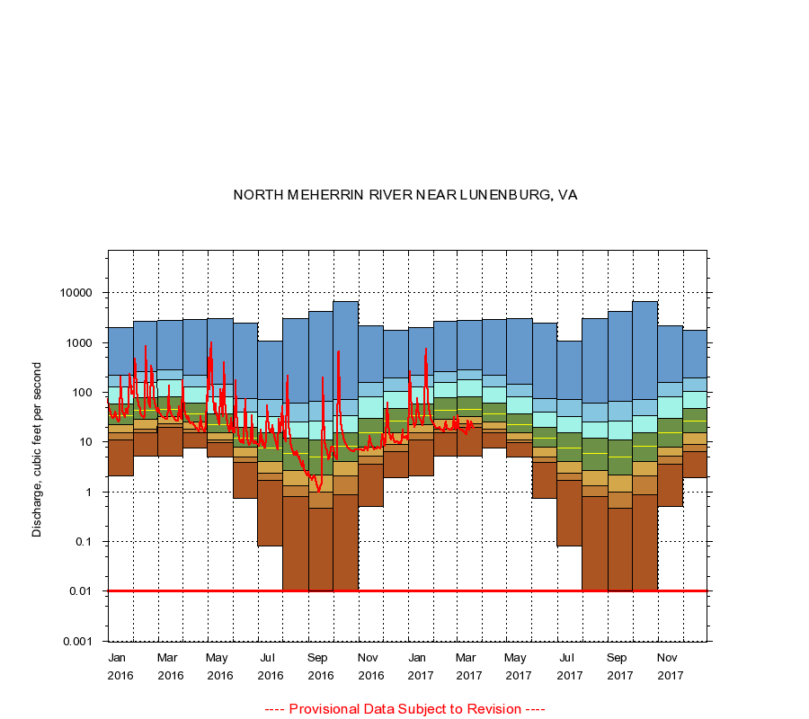
NORTH MEHERRIN RIVER NEAR LUNENBURG, VA
|
Minimum daily flow
|
|
|
5th percentile
|
|
|
|
10th percentile
|
|
|
|
|
25th percentile
|
|
|
|
|
|
Median
|
|
|
|
|
|
|
75th percentile
|
|
|
|
|
|
|
|
90th percentile
|
|
|
|
|
|
|
|
|
95th percentile
|
|
|
|
|
|
|
|
|
|
Maximum daily flow
|
|
|
|
|
|
|
|
|
|
|
|
Years of record
|
January
|
2.10
|
11.0
|
15.0
|
22.0
|
34.0
|
59.0
|
130
|
218
|
1,970
|
|
68
|
February
|
5.20
|
15.0
|
18.0
|
29.0
|
44.0
|
77.0
|
160
|
254
|
2,660
|
|
68
|
March
|
5.10
|
20.0
|
23.0
|
32.0
|
46.0
|
80.8
|
180
|
278
|
2,780
|
|
68
|
April
|
7.50
|
15.0
|
18.0
|
25.0
|
36.0
|
60.0
|
126
|
222
|
2,850
|
|
68
|
May
|
5.00
|
9.50
|
11.0
|
15.0
|
22.0
|
36.0
|
81.0
|
147
|
2,960
|
|
68
|
June
|
0.72
|
3.80
|
4.90
|
7.80
|
12.0
|
20.0
|
40.0
|
74.9
|
2,420
|
|
68
|
July
|
0.08
|
1.70
|
2.39
|
4.00
|
7.50
|
15.0
|
33.0
|
70.0
|
1,050
|
|
68
|
August
|
0.00
|
0.80
|
1.30
|
2.70
|
5.80
|
12.0
|
25.0
|
60.0
|
2,970
|
|
68
|
September
|
0.00
|
0.47
|
0.98
|
2.20
|
5.00
|
11.0
|
26.0
|
65.9
|
4,180
|
|
68
|
October
|
0.00
|
0.85
|
2.10
|
4.10
|
8.10
|
15.0
|
34.0
|
70.0
|
6,710
|
|
68
|
November
|
0.51
|
3.60
|
5.10
|
7.80
|
15.0
|
30.0
|
80.0
|
160
|
2,200
|
|
68
|
December
|
1.90
|
6.34
|
8.90
|
15.0
|
26.0
|
48.0
|
104
|
194
|
1,730
|
|
68
|
|
|
Instantaneous minimum flow for period of record =
0.00
cubic feet per second.
Flow values of 0.00 are plotted as 0.01
The current daily value for 03/22/2017 is 19.0 cubic feet per second.
----
Provisional Data Subject to Revision ----
|