|
02051500
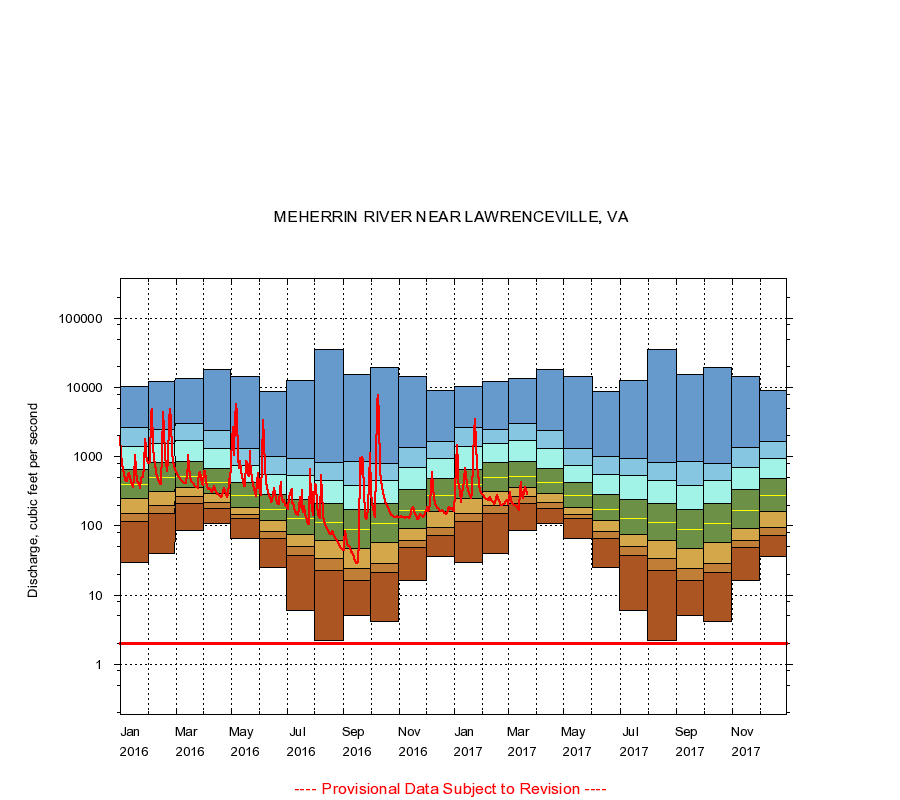
MEHERRIN RIVER NEAR LAWRENCEVILLE, VA
|
Minimum daily flow
|
|
|
5th percentile
|
|
|
|
10th percentile
|
|
|
|
|
25th percentile
|
|
|
|
|
|
Median
|
|
|
|
|
|
|
75th percentile
|
|
|
|
|
|
|
|
90th percentile
|
|
|
|
|
|
|
|
|
95th percentile
|
|
|
|
|
|
|
|
|
|
Maximum daily flow
|
|
|
|
|
|
|
|
|
|
|
|
Years of record
|
January
|
30.0
|
114
|
153
|
245
|
393
|
651
|
1,400
|
2,620
|
10,400
|
|
87
|
February
|
40.0
|
150
|
194
|
317
|
500
|
812
|
1,530
|
2,460
|
12,200
|
|
87
|
March
|
86.0
|
210
|
262
|
356
|
524
|
844
|
1,700
|
3,010
|
13,500
|
|
87
|
April
|
110
|
176
|
218
|
295
|
426
|
676
|
1,310
|
2,380
|
18,000
|
|
87
|
May
|
65.0
|
128
|
146
|
187
|
275
|
427
|
741
|
1,320
|
14,300
|
|
87
|
June
|
25.0
|
66.6
|
82.0
|
118
|
173
|
283
|
558
|
1,020
|
8,720
|
|
87
|
July
|
5.90
|
36.9
|
50.0
|
76.0
|
129
|
238
|
533
|
943
|
12,600
|
|
87
|
August
|
2.20
|
23.0
|
34.0
|
62.0
|
113
|
210
|
451
|
812
|
35,300
|
|
87
|
September
|
5.00
|
16.0
|
24.0
|
47.0
|
89.0
|
170
|
384
|
849
|
15,400
|
|
87
|
October
|
4.20
|
21.0
|
29.0
|
57.0
|
108
|
212
|
455
|
800
|
19,200
|
|
86
|
November
|
16.0
|
48.0
|
61.0
|
93.0
|
168
|
330
|
708
|
1,350
|
14,600
|
|
86
|
December
|
36.0
|
72.0
|
94.7
|
159
|
278
|
485
|
941
|
1,660
|
8,900
|
|
86
|
|
|
Instantaneous minimum flow for period of record =
2.00
cubic feet per second.
The current daily value for 03/22/2017 is 280.0 cubic feet per second.
----
Provisional Data Subject to Revision ----
|