|
02053800
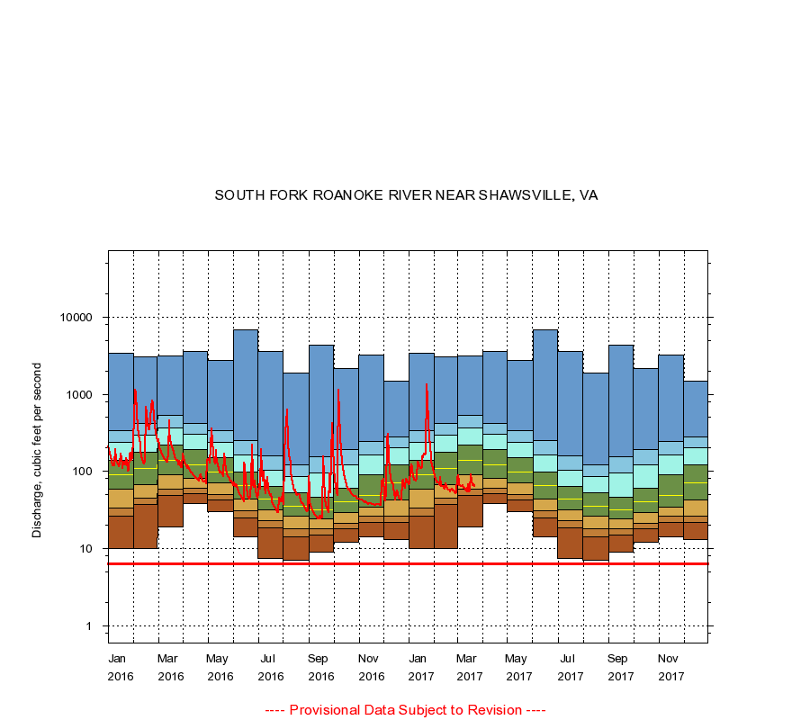
SOUTH FORK ROANOKE RIVER NEAR SHAWSVILLE, VA
|
Minimum daily flow
|
|
|
5th percentile
|
|
|
|
10th percentile
|
|
|
|
|
25th percentile
|
|
|
|
|
|
Median
|
|
|
|
|
|
|
75th percentile
|
|
|
|
|
|
|
|
90th percentile
|
|
|
|
|
|
|
|
|
95th percentile
|
|
|
|
|
|
|
|
|
|
Maximum daily flow
|
|
|
|
|
|
|
|
|
|
|
|
Years of record
|
January
|
10.0
|
26.0
|
33.0
|
58.0
|
90.0
|
139
|
240
|
335
|
3,420
|
|
55
|
February
|
10.0
|
37.0
|
45.0
|
68.0
|
108
|
176
|
297
|
421
|
3,030
|
|
55
|
March
|
19.0
|
49.0
|
59.0
|
90.0
|
140
|
218
|
361
|
538
|
3,160
|
|
55
|
April
|
38.0
|
51.0
|
61.0
|
81.0
|
120
|
190
|
303
|
423
|
3,590
|
|
55
|
May
|
30.0
|
43.0
|
50.0
|
70.0
|
98.0
|
149
|
236
|
334
|
2,730
|
|
55
|
June
|
14.0
|
25.0
|
31.0
|
44.0
|
66.0
|
99.0
|
164
|
248
|
6,840
|
|
55
|
July
|
7.50
|
18.3
|
23.0
|
32.0
|
44.0
|
64.0
|
103
|
160
|
3,570
|
|
55
|
August
|
7.00
|
14.0
|
18.0
|
26.0
|
35.0
|
53.0
|
86.0
|
121
|
1,860
|
|
55
|
September
|
9.00
|
15.0
|
18.0
|
24.0
|
32.0
|
46.0
|
96.0
|
156
|
4,270
|
|
55
|
October
|
12.0
|
18.0
|
21.0
|
29.0
|
40.0
|
61.0
|
120
|
190
|
2,130
|
|
55
|
November
|
14.0
|
22.0
|
26.0
|
34.0
|
48.5
|
91.2
|
163
|
241
|
3,180
|
|
55
|
December
|
13.0
|
22.0
|
26.0
|
42.0
|
71.0
|
120
|
201
|
276
|
1,490
|
|
55
|
|
|
Instantaneous minimum flow for period of record =
6.30
cubic feet per second.
The current daily value for 03/22/2017 is 63.0 cubic feet per second.
----
Provisional Data Subject to Revision ----
|