|
02056900
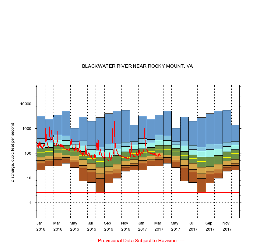
BLACKWATER RIVER NEAR ROCKY MOUNT, VA
|
Minimum daily flow
|
|
|
5th percentile
|
|
|
|
10th percentile
|
|
|
|
|
25th percentile
|
|
|
|
|
|
Median
|
|
|
|
|
|
|
75th percentile
|
|
|
|
|
|
|
|
90th percentile
|
|
|
|
|
|
|
|
|
95th percentile
|
|
|
|
|
|
|
|
|
|
Maximum daily flow
|
|
|
|
|
|
|
|
|
|
|
|
Years of record
|
January
|
21.0
|
40.0
|
50.0
|
70.0
|
108
|
152
|
249
|
396
|
3,200
|
|
39
|
February
|
31.0
|
48.0
|
55.2
|
77.0
|
118
|
170
|
265
|
362
|
2,390
|
|
39
|
March
|
30.0
|
57.0
|
69.0
|
102
|
144
|
212
|
343
|
553
|
3,580
|
|
39
|
April
|
39.0
|
60.0
|
67.0
|
87.8
|
140
|
209
|
333
|
504
|
4,990
|
|
39
|
May
|
26.0
|
45.0
|
53.0
|
78.0
|
116
|
158
|
220
|
295
|
1,010
|
|
39
|
June
|
7.60
|
25.0
|
32.0
|
55.0
|
83.0
|
120
|
200
|
318
|
2,910
|
|
39
|
July
|
6.50
|
17.0
|
22.0
|
39.0
|
61.0
|
87.0
|
141
|
208
|
1,990
|
|
39
|
August
|
2.70
|
9.60
|
15.0
|
27.0
|
47.0
|
71.0
|
121
|
178
|
2,770
|
|
39
|
September
|
6.40
|
14.6
|
19.0
|
29.0
|
45.0
|
69.0
|
142
|
239
|
4,030
|
|
39
|
October
|
9.80
|
16.0
|
23.0
|
36.0
|
48.0
|
83.0
|
149
|
236
|
5,000
|
|
39
|
November
|
19.0
|
27.0
|
32.1
|
48.0
|
68.0
|
116
|
188
|
275
|
5,410
|
|
39
|
December
|
21.0
|
32.0
|
39.0
|
57.5
|
98.0
|
140
|
214
|
300
|
1,370
|
|
39
|
|
|
Instantaneous minimum flow for period of record =
2.60
cubic feet per second.
The current daily value for 03/22/2017 is 82.0 cubic feet per second.
----
Provisional Data Subject to Revision ----
|