|
02061000
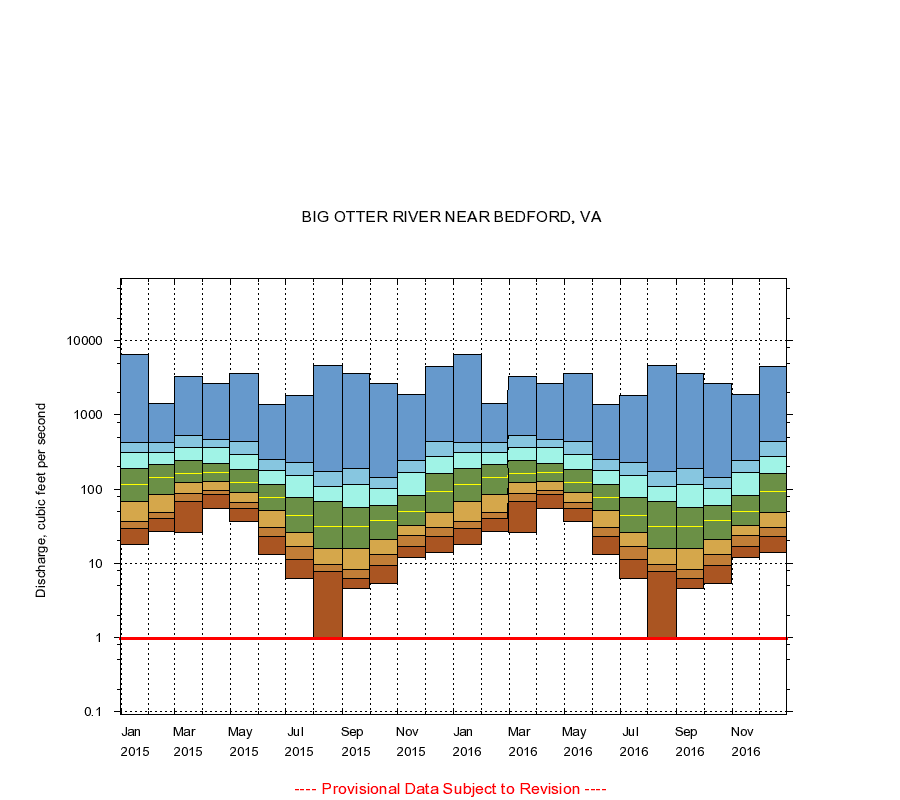
BIG OTTER RIVER NEAR BEDFORD, VA
|
Minimum daily flow
|
|
|
5th percentile
|
|
|
|
10th percentile
|
|
|
|
|
25th percentile
|
|
|
|
|
|
Median
|
|
|
|
|
|
|
75th percentile
|
|
|
|
|
|
|
|
90th percentile
|
|
|
|
|
|
|
|
|
95th percentile
|
|
|
|
|
|
|
|
|
|
Maximum daily flow
|
|
|
|
|
|
|
|
|
|
|
|
Years of record
|
January
|
18.0
|
29.0
|
36.0
|
68.0
|
115
|
190
|
313
|
425
|
6,490
|
|
25
|
February
|
27.0
|
40.0
|
48.0
|
85.0
|
144
|
215
|
312
|
421
|
1,430
|
|
25
|
March
|
26.0
|
68.0
|
88.0
|
123
|
163
|
243
|
368
|
529
|
3,340
|
|
25
|
April
|
54.0
|
84.0
|
95.1
|
126
|
168
|
222
|
364
|
460
|
2,690
|
|
25
|
May
|
36.0
|
54.0
|
66.0
|
90.0
|
124
|
184
|
291
|
433
|
3,660
|
|
25
|
June
|
13.0
|
23.0
|
30.0
|
51.0
|
76.0
|
114
|
180
|
254
|
1,370
|
|
25
|
July
|
6.20
|
11.2
|
17.0
|
26.0
|
44.0
|
77.0
|
152
|
229
|
1,810
|
|
24
|
August
|
1.00
|
7.65
|
9.60
|
16.0
|
31.0
|
67.0
|
109
|
170
|
4,640
|
|
24
|
September
|
4.60
|
6.20
|
8.20
|
16.0
|
31.0
|
57.0
|
116
|
189
|
3,640
|
|
24
|
October
|
5.30
|
9.40
|
13.0
|
21.0
|
38.0
|
60.0
|
102
|
144
|
2,620
|
|
24
|
November
|
12.0
|
17.0
|
24.0
|
32.0
|
50.0
|
82.0
|
165
|
244
|
1,870
|
|
24
|
December
|
14.0
|
23.0
|
30.0
|
48.0
|
94.0
|
160
|
277
|
435
|
4,530
|
|
24
|
|
|
Instantaneous minimum flow for period of record =
0.97
cubic feet per second.
The current daily value for 08/22/2016 is not determined.
----
Provisional Data Subject to Revision ----
|