|
02061500
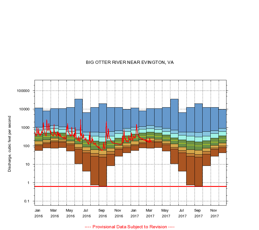
BIG OTTER RIVER NEAR EVINGTON, VA
|
Minimum daily flow
|
|
|
5th percentile
|
|
|
|
10th percentile
|
|
|
|
|
25th percentile
|
|
|
|
|
|
Median
|
|
|
|
|
|
|
75th percentile
|
|
|
|
|
|
|
|
90th percentile
|
|
|
|
|
|
|
|
|
95th percentile
|
|
|
|
|
|
|
|
|
|
Maximum daily flow
|
|
|
|
|
|
|
|
|
|
|
|
Years of record
|
January
|
57.0
|
103
|
121
|
188
|
280
|
436
|
727
|
1,060
|
11,700
|
|
78
|
February
|
78.0
|
136
|
160
|
216
|
330
|
513
|
800
|
1,130
|
8,140
|
|
78
|
March
|
75.0
|
167
|
191
|
262
|
374
|
557
|
888
|
1,290
|
10,700
|
|
78
|
April
|
81.0
|
160
|
185
|
234
|
335
|
506
|
793
|
1,090
|
10,700
|
|
79
|
May
|
52.0
|
116
|
138
|
185
|
265
|
393
|
600
|
889
|
12,400
|
|
79
|
June
|
11.0
|
67.0
|
83.0
|
128
|
198
|
281
|
478
|
729
|
35,700
|
|
79
|
July
|
4.20
|
42.0
|
56.0
|
87.0
|
139
|
212
|
377
|
558
|
6,440
|
|
79
|
August
|
0.75
|
28.0
|
39.0
|
63.0
|
112
|
186
|
344
|
567
|
12,400
|
|
79
|
September
|
0.64
|
25.0
|
34.0
|
58.0
|
100
|
165
|
313
|
544
|
20,200
|
|
79
|
October
|
8.40
|
36.0
|
51.9
|
77.0
|
119
|
195
|
344
|
600
|
12,700
|
|
78
|
November
|
28.0
|
66.0
|
79.0
|
108
|
162
|
265
|
476
|
690
|
12,400
|
|
78
|
December
|
42.0
|
80.0
|
100
|
143
|
230
|
356
|
614
|
915
|
9,700
|
|
78
|
|
|
Instantaneous minimum flow for period of record =
0.63
cubic feet per second.
The current daily value for 03/22/2017 is 161.0 cubic feet per second.
----
Provisional Data Subject to Revision ----
|