|
02064000
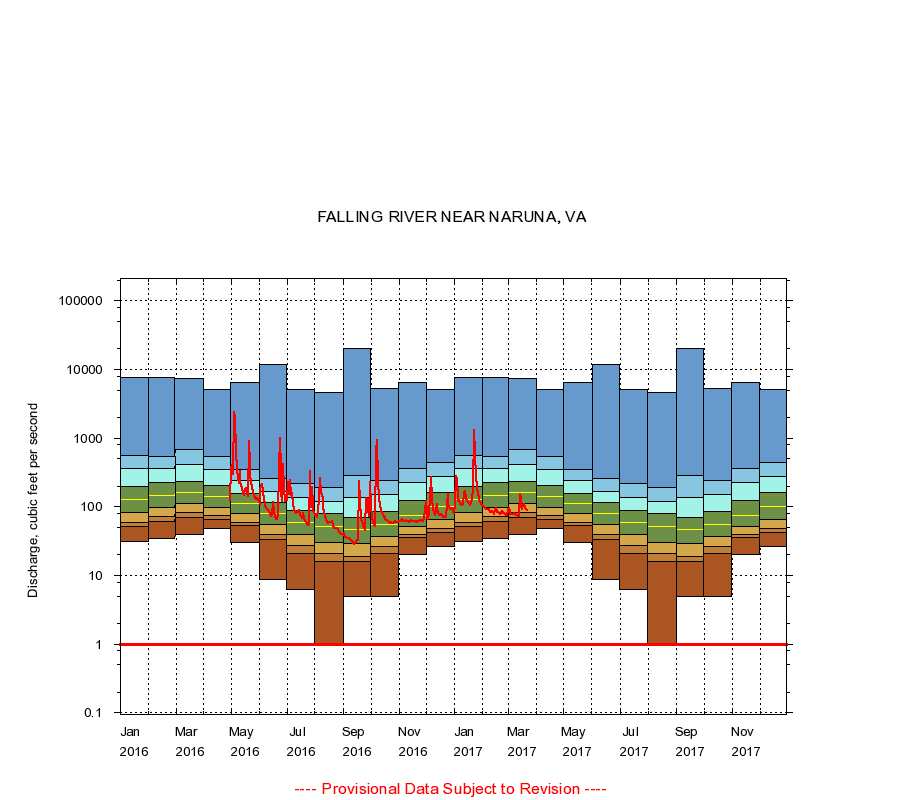
FALLING RIVER NEAR NARUNA, VA
|
Minimum daily flow
|
|
|
5th percentile
|
|
|
|
10th percentile
|
|
|
|
|
25th percentile
|
|
|
|
|
|
Median
|
|
|
|
|
|
|
75th percentile
|
|
|
|
|
|
|
|
90th percentile
|
|
|
|
|
|
|
|
|
95th percentile
|
|
|
|
|
|
|
|
|
|
Maximum daily flow
|
|
|
|
|
|
|
|
|
|
|
|
Years of record
|
January
|
31.0
|
51.0
|
60.0
|
82.0
|
126
|
201
|
356
|
551
|
7,570
|
|
79
|
February
|
35.0
|
62.0
|
73.0
|
99.0
|
145
|
230
|
367
|
549
|
7,770
|
|
79
|
March
|
40.0
|
69.0
|
83.0
|
110
|
160
|
236
|
418
|
676
|
7,460
|
|
78
|
April
|
48.0
|
66.0
|
75.0
|
99.0
|
141
|
206
|
350
|
544
|
5,060
|
|
78
|
May
|
30.0
|
53.0
|
60.0
|
79.0
|
113
|
158
|
242
|
349
|
6,400
|
|
78
|
June
|
8.80
|
33.0
|
40.0
|
56.0
|
80.0
|
114
|
167
|
255
|
12,000
|
|
78
|
July
|
6.30
|
21.0
|
27.0
|
39.0
|
60.0
|
89.0
|
136
|
219
|
5,100
|
|
78
|
August
|
1.00
|
16.0
|
21.0
|
30.0
|
51.0
|
79.0
|
121
|
191
|
4,640
|
|
78
|
September
|
5.00
|
16.0
|
19.1
|
29.0
|
47.0
|
70.0
|
136
|
282
|
20,000
|
|
78
|
October
|
5.00
|
21.0
|
26.0
|
37.0
|
55.0
|
86.5
|
151
|
239
|
5,320
|
|
79
|
November
|
20.0
|
36.0
|
39.0
|
51.8
|
74.0
|
122
|
226
|
358
|
6,430
|
|
79
|
December
|
26.0
|
42.0
|
48.0
|
65.0
|
102
|
161
|
281
|
436
|
5,070
|
|
79
|
|
|
Instantaneous minimum flow for period of record =
1.00
cubic feet per second.
The current daily value for 03/22/2017 is 89.0 cubic feet per second.
----
Provisional Data Subject to Revision ----
|