|
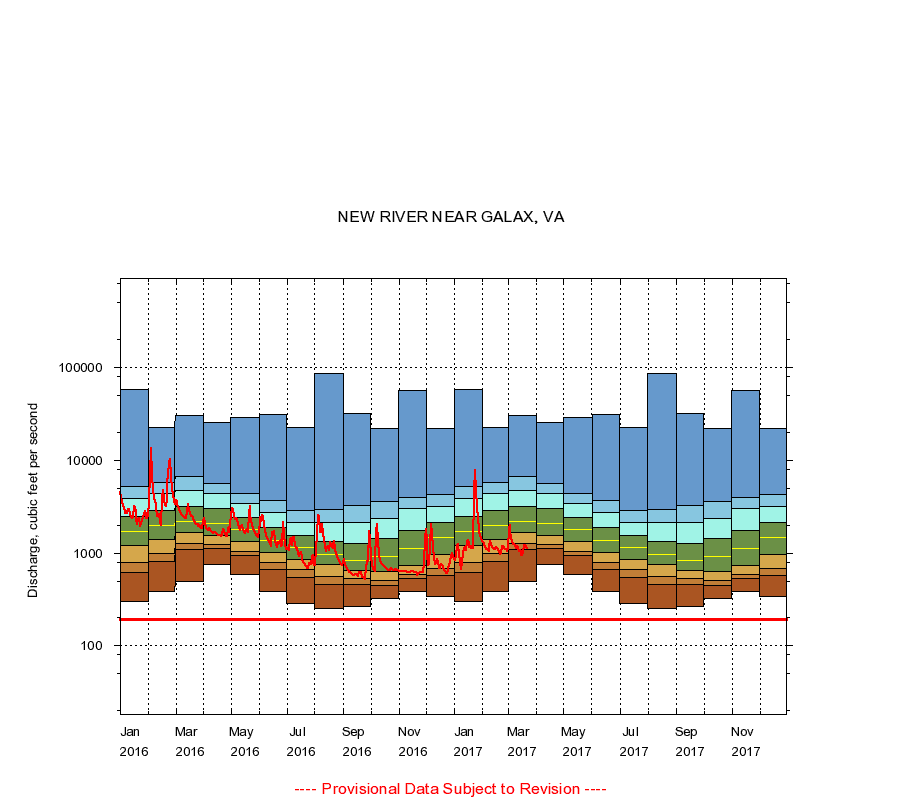
03164000
NEW RIVER NEAR GALAX, VA
|
Minimum daily flow
|
|
|
5th percentile
|
|
|
|
10th percentile
|
|
|
|
|
25th percentile
|
|
|
|
|
|
Median
|
|
|
|
|
|
|
75th percentile
|
|
|
|
|
|
|
|
90th percentile
|
|
|
|
|
|
|
|
|
95th percentile
|
|
|
|
|
|
|
|
|
|
Maximum daily flow
|
|
|
|
|
|
|
|
|
|
|
|
Years of record
|
January
|
300
|
620
|
799
|
1,210
|
1,720
|
2,500
|
3,870
|
5,180
|
57,800
|
|
86
|
February
|
390
|
818
|
1,000
|
1,400
|
2,000
|
2,870
|
4,360
|
5,710
|
22,500
|
|
86
|
March
|
500
|
1,080
|
1,270
|
1,680
|
2,210
|
3,190
|
4,730
|
6,650
|
30,600
|
|
86
|
April
|
755
|
1,110
|
1,250
|
1,540
|
2,110
|
3,000
|
4,390
|
5,610
|
25,400
|
|
86
|
May
|
582
|
932
|
1,040
|
1,330
|
1,780
|
2,430
|
3,440
|
4,430
|
29,100
|
|
86
|
June
|
383
|
669
|
782
|
1,010
|
1,380
|
1,910
|
2,770
|
3,680
|
31,000
|
|
86
|
July
|
285
|
549
|
659
|
856
|
1,140
|
1,530
|
2,160
|
2,890
|
22,900
|
|
86
|
August
|
250
|
454
|
562
|
751
|
956
|
1,350
|
2,160
|
2,980
|
86,200
|
|
86
|
September
|
265
|
460
|
530
|
647
|
842
|
1,260
|
2,120
|
3,260
|
32,100
|
|
86
|
October
|
322
|
444
|
503
|
635
|
926
|
1,430
|
2,380
|
3,600
|
22,000
|
|
86
|
November
|
388
|
537
|
587
|
743
|
1,120
|
1,760
|
3,000
|
3,980
|
56,800
|
|
86
|
December
|
340
|
580
|
676
|
954
|
1,460
|
2,140
|
3,200
|
4,310
|
22,000
|
|
86
|
|
|
Instantaneous minimum flow for period of record =
193
cubic feet per second.
The current daily value for 03/22/2017 is 1120.0 cubic feet per second.
----
Provisional Data Subject to Revision ----
|