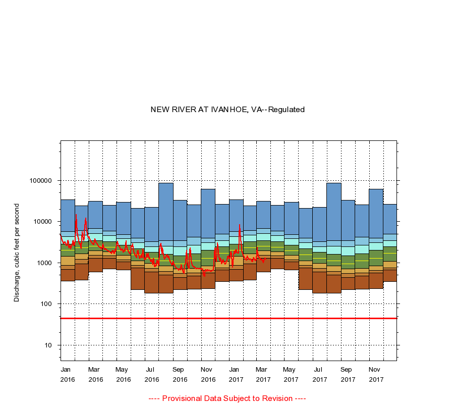
|
03165500
NEW RIVER AT IVANHOE, VA
|
Minimum daily flow
|
|
|
5th percentile
|
|
|
|
10th percentile
|
|
|
|
|
25th percentile
|
|
|
|
|
|
Median
|
|
|
|
|
|
|
75th percentile
|
|
|
|
|
|
|
|
90th percentile
|
|
|
|
|
|
|
|
|
95th percentile
|
|
|
|
|
|
|
|
|
|
Maximum daily flow
|
|
|
|
|
|
|
|
|
|
|
|
Years of record
|
January
|
358
|
696
|
871
|
1,420
|
2,030
|
2,850
|
4,360
|
5,700
|
33,700
|
|
68
|
February
|
384
|
951
|
1,210
|
1,650
|
2,340
|
3,220
|
4,710
|
6,060
|
24,600
|
|
69
|
March
|
607
|
1,280
|
1,520
|
1,990
|
2,500
|
3,460
|
5,090
|
6,900
|
31,400
|
|
69
|
April
|
716
|
1,300
|
1,460
|
1,860
|
2,420
|
3,230
|
4,550
|
5,950
|
25,200
|
|
69
|
May
|
672
|
1,060
|
1,190
|
1,520
|
1,990
|
2,660
|
3,850
|
4,850
|
29,300
|
|
69
|
June
|
224
|
746
|
854
|
1,110
|
1,560
|
2,190
|
3,070
|
3,990
|
21,300
|
|
69
|
July
|
184
|
601
|
722
|
960
|
1,300
|
1,780
|
2,470
|
3,310
|
22,500
|
|
69
|
August
|
181
|
500
|
618
|
832
|
1,120
|
1,600
|
2,560
|
3,450
|
87,600
|
|
70
|
September
|
220
|
435
|
544
|
705
|
950
|
1,480
|
2,460
|
3,410
|
33,100
|
|
70
|
October
|
232
|
478
|
570
|
736
|
1,110
|
1,650
|
2,650
|
4,200
|
25,400
|
|
69
|
November
|
238
|
572
|
658
|
848
|
1,300
|
2,000
|
3,120
|
4,000
|
61,200
|
|
69
|
December
|
350
|
662
|
755
|
1,080
|
1,710
|
2,470
|
3,500
|
5,000
|
26,100
|
|
69
|
|
|
Instantaneous minimum flow for period of record =
44.0
cubic feet per second.
The current daily value for 03/22/2017 is 1200.0 cubic feet per second.
----
Provisional Data Subject to Revision ----
|