|
03167000
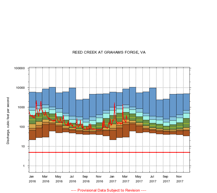
REED CREEK AT GRAHAMS FORGE, VA
|
Minimum daily flow
|
|
|
5th percentile
|
|
|
|
10th percentile
|
|
|
|
|
25th percentile
|
|
|
|
|
|
Median
|
|
|
|
|
|
|
75th percentile
|
|
|
|
|
|
|
|
90th percentile
|
|
|
|
|
|
|
|
|
95th percentile
|
|
|
|
|
|
|
|
|
|
Maximum daily flow
|
|
|
|
|
|
|
|
|
|
|
|
Years of record
|
January
|
22.0
|
66.0
|
84.0
|
141
|
227
|
389
|
699
|
1,000
|
6,080
|
|
96
|
February
|
28.0
|
88.0
|
120
|
190
|
304
|
505
|
832
|
1,230
|
5,660
|
|
96
|
March
|
30.0
|
130
|
174
|
244
|
358
|
549
|
928
|
1,330
|
8,760
|
|
96
|
April
|
60.0
|
143
|
165
|
211
|
301
|
462
|
750
|
1,050
|
10,600
|
|
97
|
May
|
50.0
|
109
|
126
|
163
|
222
|
330
|
560
|
840
|
5,600
|
|
97
|
June
|
54.0
|
78.0
|
88.0
|
114
|
152
|
222
|
360
|
491
|
6,160
|
|
97
|
July
|
48.0
|
68.0
|
74.0
|
91.0
|
115
|
154
|
240
|
350
|
9,880
|
|
97
|
August
|
43.0
|
60.0
|
68.0
|
81.0
|
102
|
138
|
226
|
327
|
2,450
|
|
97
|
September
|
41.0
|
57.0
|
63.0
|
72.0
|
87.0
|
111
|
172
|
248
|
2,640
|
|
97
|
October
|
42.0
|
56.0
|
62.0
|
73.0
|
90.0
|
129
|
210
|
320
|
4,650
|
|
96
|
November
|
40.0
|
63.0
|
68.0
|
78.0
|
103
|
166
|
290
|
421
|
4,800
|
|
96
|
December
|
34.0
|
64.0
|
69.0
|
94.0
|
147
|
275
|
497
|
706
|
4,910
|
|
96
|
|
|
Instantaneous minimum flow for period of record =
5.00
cubic feet per second.
The current daily value for 03/22/2017 is 256.0 cubic feet per second.
----
Provisional Data Subject to Revision ----
|