|
03168000
NEW RIVER AT ALLISONIA, VA
|
Minimum daily flow
|
|
|
5th percentile
|
|
|
|
10th percentile
|
|
|
|
|
25th percentile
|
|
|
|
|
|
Median
|
|
|
|
|
|
|
75th percentile
|
|
|
|
|
|
|
|
90th percentile
|
|
|
|
|
|
|
|
|
95th percentile
|
|
|
|
|
|
|
|
|
|
Maximum daily flow
|
|
|
|
|
|
|
|
|
|
|
|
Years of record
|
January
|
500
|
990
|
1,210
|
1,980
|
2,920
|
4,230
|
6,560
|
8,530
|
84,700
|
|
86
|
February
|
662
|
1,280
|
1,640
|
2,320
|
3,450
|
5,020
|
7,460
|
9,870
|
38,100
|
|
86
|
March
|
939
|
1,760
|
2,130
|
2,890
|
3,860
|
5,410
|
8,460
|
11,400
|
50,900
|
|
86
|
April
|
1,100
|
1,810
|
2,060
|
2,610
|
3,640
|
5,180
|
7,550
|
9,690
|
44,100
|
|
86
|
May
|
997
|
1,470
|
1,710
|
2,250
|
3,040
|
4,280
|
6,020
|
7,720
|
46,100
|
|
86
|
June
|
627
|
1,080
|
1,260
|
1,680
|
2,350
|
3,260
|
4,530
|
6,050
|
56,500
|
|
86
|
July
|
535
|
918
|
1,100
|
1,410
|
1,880
|
2,560
|
3,600
|
4,950
|
30,900
|
|
86
|
August
|
369
|
777
|
947
|
1,220
|
1,620
|
2,230
|
3,480
|
4,900
|
95,000
|
|
86
|
September
|
446
|
751
|
866
|
1,060
|
1,390
|
2,030
|
3,350
|
4,840
|
59,200
|
|
86
|
October
|
534
|
760
|
857
|
1,060
|
1,510
|
2,280
|
3,700
|
5,600
|
38,300
|
|
86
|
November
|
608
|
885
|
986
|
1,230
|
1,820
|
2,810
|
4,530
|
6,040
|
86,500
|
|
86
|
December
|
600
|
941
|
1,100
|
1,580
|
2,400
|
3,530
|
5,270
|
7,160
|
36,200
|
|
86
|
|
|
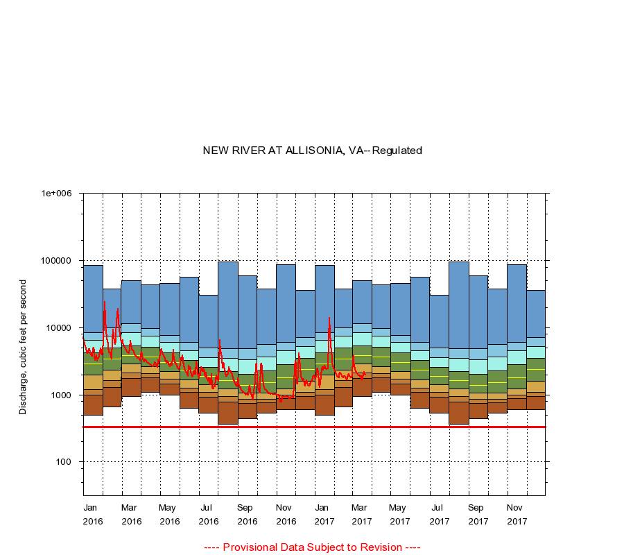
Instantaneous minimum flow for period of record =
335
cubic feet per second.
The current daily value for 03/22/2017 is 1970.0 cubic feet per second.
----
Provisional Data Subject to Revision ----
|