|
03170000
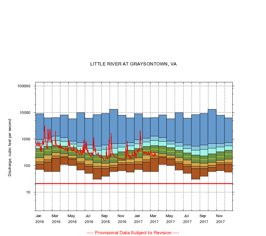
LITTLE RIVER AT GRAYSONTOWN, VA
|
Minimum daily flow
|
|
|
5th percentile
|
|
|
|
10th percentile
|
|
|
|
|
25th percentile
|
|
|
|
|
|
Median
|
|
|
|
|
|
|
75th percentile
|
|
|
|
|
|
|
|
90th percentile
|
|
|
|
|
|
|
|
|
95th percentile
|
|
|
|
|
|
|
|
|
|
Maximum daily flow
|
|
|
|
|
|
|
|
|
|
|
|
Years of record
|
January
|
71.0
|
112
|
138
|
200
|
308
|
442
|
667
|
954
|
9,000
|
|
87
|
February
|
60.0
|
135
|
168
|
250
|
366
|
520
|
772
|
1,080
|
6,300
|
|
87
|
March
|
60.0
|
191
|
229
|
306
|
416
|
568
|
886
|
1,300
|
6,440
|
|
87
|
April
|
110
|
205
|
228
|
279
|
390
|
542
|
810
|
1,140
|
8,090
|
|
87
|
May
|
103
|
173
|
192
|
245
|
344
|
472
|
645
|
845
|
5,860
|
|
87
|
June
|
68.0
|
118
|
139
|
199
|
276
|
373
|
541
|
735
|
10,000
|
|
87
|
July
|
51.0
|
94.0
|
110
|
160
|
218
|
300
|
440
|
596
|
6,170
|
|
87
|
August
|
31.0
|
76.9
|
95.0
|
129
|
181
|
250
|
375
|
544
|
8,470
|
|
87
|
September
|
40.0
|
78.0
|
93.0
|
122
|
165
|
230
|
411
|
599
|
9,330
|
|
87
|
October
|
59.0
|
85.0
|
101
|
132
|
180
|
274
|
452
|
680
|
13,200
|
|
87
|
November
|
65.0
|
111
|
128
|
157
|
215
|
330
|
497
|
687
|
8,020
|
|
87
|
December
|
57.0
|
110
|
130
|
177
|
267
|
381
|
558
|
739
|
6,260
|
|
87
|
|
|
Instantaneous minimum flow for period of record =
21.0
cubic feet per second.
The current daily value for 03/22/2017 is 242.0 cubic feet per second.
----
Provisional Data Subject to Revision ----
|