|
03175500
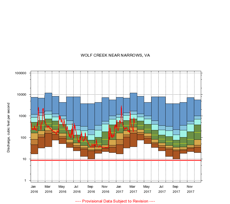
WOLF CREEK NEAR NARROWS, VA
|
Minimum daily flow
|
|
|
5th percentile
|
|
|
|
10th percentile
|
|
|
|
|
25th percentile
|
|
|
|
|
|
Median
|
|
|
|
|
|
|
75th percentile
|
|
|
|
|
|
|
|
90th percentile
|
|
|
|
|
|
|
|
|
95th percentile
|
|
|
|
|
|
|
|
|
|
Maximum daily flow
|
|
|
|
|
|
|
|
|
|
|
|
Years of record
|
January
|
17.0
|
46.0
|
81.0
|
161
|
287
|
508
|
868
|
1,200
|
7,360
|
|
84
|
February
|
32.0
|
104
|
132
|
210
|
369
|
622
|
1,060
|
1,410
|
6,860
|
|
84
|
March
|
37.0
|
159
|
207
|
305
|
460
|
730
|
1,200
|
1,720
|
11,700
|
|
84
|
April
|
76.0
|
139
|
172
|
240
|
358
|
585
|
900
|
1,250
|
8,380
|
|
85
|
May
|
51.0
|
95.0
|
113
|
159
|
245
|
414
|
726
|
1,020
|
4,310
|
|
85
|
June
|
34.0
|
51.0
|
59.0
|
81.0
|
129
|
221
|
405
|
598
|
7,890
|
|
85
|
July
|
24.0
|
35.0
|
42.0
|
56.0
|
84.0
|
131
|
223
|
362
|
7,800
|
|
85
|
August
|
13.0
|
29.0
|
33.0
|
43.0
|
65.0
|
109
|
206
|
328
|
3,720
|
|
86
|
September
|
10.0
|
24.0
|
27.0
|
35.0
|
50.0
|
76.0
|
134
|
230
|
3,760
|
|
86
|
October
|
18.0
|
25.0
|
28.0
|
36.0
|
53.0
|
103
|
219
|
370
|
4,320
|
|
84
|
November
|
22.0
|
31.0
|
35.0
|
45.0
|
82.0
|
186
|
424
|
570
|
7,280
|
|
84
|
December
|
20.0
|
35.0
|
44.0
|
80.0
|
172
|
384
|
701
|
1,010
|
5,690
|
|
84
|
|
|
Instantaneous minimum flow for period of record =
8.80
cubic feet per second.
The current daily value for 03/22/2017 is 465.0 cubic feet per second.
----
Provisional Data Subject to Revision ----
|