|
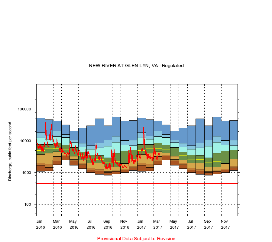
03176500
NEW RIVER AT GLEN LYN, VA
|
Minimum daily flow
|
|
|
5th percentile
|
|
|
|
10th percentile
|
|
|
|
|
25th percentile
|
|
|
|
|
|
Median
|
|
|
|
|
|
|
75th percentile
|
|
|
|
|
|
|
|
90th percentile
|
|
|
|
|
|
|
|
|
95th percentile
|
|
|
|
|
|
|
|
|
|
Maximum daily flow
|
|
|
|
|
|
|
|
|
|
|
|
Years of record
|
January
|
1,100
|
1,700
|
2,020
|
3,740
|
4,950
|
7,770
|
12,600
|
18,300
|
52,300
|
|
12
|
February
|
1,150
|
1,440
|
1,840
|
4,080
|
5,680
|
7,800
|
11,300
|
14,400
|
46,700
|
|
12
|
March
|
1,760
|
2,330
|
3,240
|
4,540
|
5,820
|
8,610
|
13,800
|
20,400
|
42,300
|
|
12
|
April
|
2,480
|
3,340
|
3,570
|
4,160
|
5,380
|
7,400
|
12,800
|
16,000
|
32,000
|
|
12
|
May
|
1,680
|
2,350
|
2,560
|
3,280
|
4,720
|
6,260
|
8,790
|
10,400
|
20,700
|
|
11
|
June
|
1,320
|
1,780
|
1,970
|
2,440
|
3,390
|
4,500
|
6,430
|
8,520
|
25,700
|
|
11
|
July
|
990
|
1,180
|
1,380
|
2,000
|
2,620
|
3,590
|
5,430
|
7,060
|
30,300
|
|
11
|
August
|
870
|
1,120
|
1,280
|
1,980
|
2,570
|
3,500
|
6,020
|
8,630
|
49,600
|
|
11
|
September
|
820
|
1,000
|
1,080
|
1,480
|
2,100
|
2,920
|
6,780
|
10,800
|
29,900
|
|
11
|
October
|
900
|
1,080
|
1,150
|
1,470
|
2,260
|
4,080
|
9,100
|
13,900
|
57,600
|
|
12
|
November
|
1,000
|
1,220
|
1,310
|
1,920
|
3,060
|
4,800
|
7,420
|
10,200
|
43,000
|
|
12
|
December
|
1,160
|
1,420
|
1,570
|
2,660
|
3,600
|
5,050
|
7,000
|
10,400
|
43,500
|
|
12
|
|
|
Instantaneous minimum flow for period of record =
449
cubic feet per second.
The current daily value for 03/22/2017 is 3520.0 cubic feet per second.
----
Provisional Data Subject to Revision ----
|