|
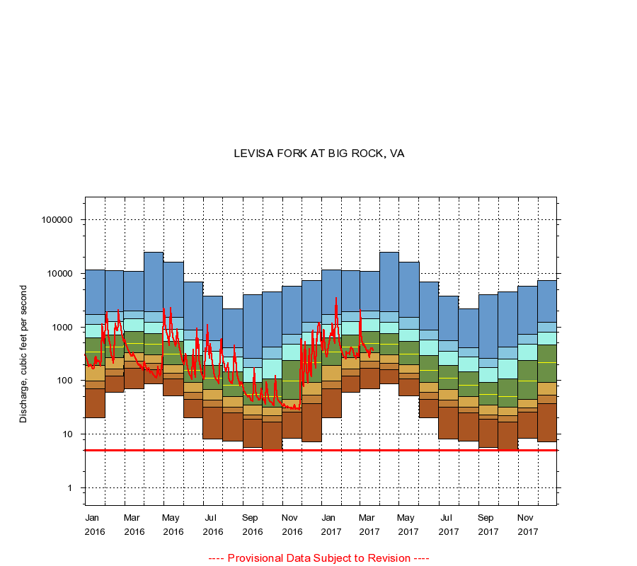
03207800
LEVISA FORK AT BIG ROCK, VA
|
Minimum daily flow
|
|
|
5th percentile
|
|
|
|
10th percentile
|
|
|
|
|
25th percentile
|
|
|
|
|
|
Median
|
|
|
|
|
|
|
75th percentile
|
|
|
|
|
|
|
|
90th percentile
|
|
|
|
|
|
|
|
|
95th percentile
|
|
|
|
|
|
|
|
|
|
Maximum daily flow
|
|
|
|
|
|
|
|
|
|
|
|
Years of record
|
January
|
20.0
|
70.0
|
98.0
|
190
|
344
|
621
|
1,130
|
1,690
|
11,600
|
|
48
|
February
|
60.0
|
123
|
164
|
268
|
422
|
702
|
1,250
|
1,900
|
11,200
|
|
48
|
March
|
70.0
|
172
|
230
|
330
|
499
|
834
|
1,420
|
2,010
|
10,900
|
|
48
|
April
|
88.0
|
162
|
210
|
304
|
476
|
747
|
1,220
|
1,940
|
24,800
|
|
48
|
May
|
52.0
|
108
|
136
|
199
|
312
|
546
|
912
|
1,490
|
16,300
|
|
48
|
June
|
20.0
|
45.0
|
60.0
|
92.2
|
153
|
296
|
566
|
873
|
6,990
|
|
48
|
July
|
8.10
|
32.0
|
43.0
|
69.0
|
112
|
190
|
354
|
547
|
3,720
|
|
48
|
August
|
7.50
|
25.0
|
32.0
|
50.0
|
82.0
|
146
|
277
|
414
|
2,190
|
|
48
|
September
|
5.60
|
19.0
|
23.1
|
35.0
|
55.0
|
93.0
|
174
|
262
|
4,050
|
|
48
|
October
|
5.10
|
17.0
|
22.0
|
32.0
|
51.0
|
109
|
250
|
418
|
4,520
|
|
48
|
November
|
8.40
|
26.0
|
31.0
|
44.2
|
99.0
|
235
|
477
|
738
|
5,710
|
|
48
|
December
|
7.20
|
37.0
|
53.0
|
94.0
|
218
|
460
|
802
|
1,220
|
7,350
|
|
48
|
|
|
Instantaneous minimum flow for period of record =
5.00
cubic feet per second.
The current daily value for 03/22/2017 is 368.0 cubic feet per second.
----
Provisional Data Subject to Revision ----
|